Ras Doumeira
| Ras Doumeira | |
|---|---|
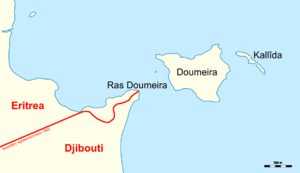 Map of Ras Doumeira with the de facto border | |
| Location | Djibouti–Eritrea border |
| Coordinates | 12°42′40″N 43°8′0″E / 12.71111°N 43.13333°ECoordinates: 12°42′40″N 43°8′0″E / 12.71111°N 43.13333°E |
Ras Doumeira (Cape Doumeira) is a geographic cape that extends into the Red Sea, towards the Doumeira Islands. The area is shared between the countries of Djibouti and Eritrea and was the subject of a 2008 border dispute.[1]
References
- ↑ "US condemns Eritrea 'aggression'". 12 June 2008. Retrieved 15 June 2008.
This article is issued from
Wikipedia.
The text is licensed under Creative Commons - Attribution - Sharealike.
Additional terms may apply for the media files.