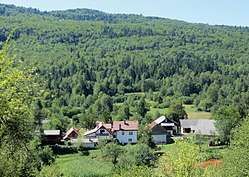
Rapljevo
| Rapljevo | |
|---|---|
 | |
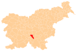
 Rapljevo Location in Slovenia | |
| Coordinates: 45°46′11.64″N 14°47′6.03″E / 45.7699000°N 14.7850083°ECoordinates: 45°46′11.64″N 14°47′6.03″E / 45.7699000°N 14.7850083°E | |
| Country |
|
| Traditional region | Lower Carniola |
| Statistical region | Central Slovenia |
| Municipality | Dobrepolje |
| Area | |
| • Total | 15.33 km2 (5.92 sq mi) |
| Elevation | 427.1 m (1,401.2 ft) |
| Population (2002) | |
| • Total | 63 |
| [1] | |
Rapljevo (pronounced [ˈɾaːpljɛʋɔ]) is a settlement in the southern part of the Municipality of Dobrepolje in Slovenia. The municipality is included in the Central Slovenia Statistical Region. The entire area is part of the historical region of Lower Carniola.[2]
References
External links

- Rapljevo at Geopedia
| Settlements | Administrative centre: Videm
|  | ||||
|---|---|---|---|---|---|---|
| Landmarks |
| |||||
| Notable people |
| |||||
This article is issued from
Wikipedia.
The text is licensed under Creative Commons - Attribution - Sharealike.
Additional terms may apply for the media files.