Ranikhet district
| Ranikhet District रानीखेत ज़िला | |
|---|---|
| District | |
 Ranikhet District Location in Uttarakhand, India  Ranikhet District Ranikhet District (India) | |
| Coordinates: 29°39′N 79°25′E / 29.65°N 79.42°ECoordinates: 29°39′N 79°25′E / 29.65°N 79.42°E | |
| Country |
|
| State | Uttarakhand |
| District | Ranikhet |
| Population | |
| • Total | 322,408 |
| Languages | |
| • Official | Hindi |
| • Regional | Kumaoni |
| Time zone | UTC+5:30 (IST) |
| Vehicle registration | UK |
| Website |
uk |
Ranikhet District is newly proposed district to split Almora district in the state of Uttarakhand, India.[1] Its area is 1397 km2 and population is 322,408[1]
Tehsils
- Ranikhet
- Salt
- Bhikiyasain
- Dwarahat
- Chaukhutia
- Syalde
Blocks
- Eight
Visiting places
Ranikhet is a hill station.
Religious places
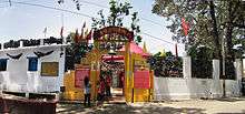
Jhula Devi Temple, Ranikhet
- Jhula Devi Temple
References
- 1 2 3 "मानक शिथिल कर उत्तराखंड में चार नए जिलों की संस्तुति". Jagran.com. Retrieved 14 August 2018.
This article is issued from
Wikipedia.
The text is licensed under Creative Commons - Attribution - Sharealike.
Additional terms may apply for the media files.