Rangefinder
A rangefinder is a device that measures distance from the observer to a target, in a process called ranging.
Techniques
Active methods use unilateral transmission and passive reflection. Active rangefinding methods include laser, radar, sonar, lidar and ultrasonic rangefinding.
Other devices measure distance using trigonometry (stadiametric rangefinders and parallax, or coincidence rangefinders). Older methodologies that use a set of known information usually distance or target sizes, to make the measurement, have been in regular use since the 18th century.
Special ranging makes use of actively synchronized transmission and travel time measurements. Hence the time difference between several received signals is used to determine exact distances. This principle is used with SatNav, the Satellite Navigation class of systems. In conjunction with a standardized model of the Globe surface a certain location on the Globe may be determined with high accuracy. Ranging methods without accurate time synchronization of the receiver are called pseudorange, used, e.g. in GPS positioning.
With other systems ranging is obtained from passive radiation measurements only. Hence the noise or radiation signature of the object is generating the signal that is computed for range. However such asynchronous method requires multiple measurements to obtain range by taking multiple bearings instead of appropriate scaling of active pings, otherwise the system is just capable to provide a simple bearing from any sole measurement.
Ranging is the term merely applying for distance metering with moving objects. Combining several metering results in a time sequence leads to tracking and tracing. A commonly used term for residing terrestrial objects is surveying.
Applications
Applications include surveying, navigation, to assist focusing in photography, choosing a golf club according to distance, and correcting aim of a projectile weapon for distance.
Golf
Laser rangefinders are used for many things today, including golf. People can use this technology not only to measure the yardage of a particular shot but to gauge slope and wind as well. The technology makes it very simple to obtain yardage. In a typical rangefinder, one aims the reticle at the flagstick and presses a button to get the yardage. There has been debate over whether they should be allowed in tournaments. While their use is banned on the professional level, they are becoming widely used on the amateur level.[1][2]
Ballistics
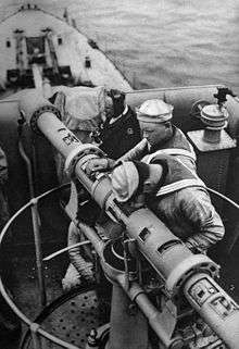
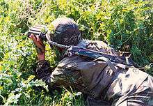
Rangefinders may be used by users of firearms over long distances, to measure the distance to a target to allow for projectile drop.[3] The laser rangefinder displays a luminous dot that may alert a target. Until the development of electronic means of measuring range during the Second World War, warships used very large optical rangefinders—with a baseline of many meters—to measure range for naval gunnery.
Forestry
Rangefinders are used for surveying in forestry. Special devices with anti-leaf filters are used.
Virtual reality
Since the 1990s, rangefinders have been used in virtual reality systems to detect operator movements and locate objects.[4]
See also
References
- ↑ "Golf Rangefinder Comparison Chart at Golfsmith." Golf Rangefinder Comparison Chart at Golfsmith. N.p., n.d. Web. 06 Nov. 2014.
- ↑ "While We're Young, USGA." Golf.com. N.p., n.d. Web. 06 Nov. 2014.
- ↑ Farey, Pat and Spicer, Mark (2009) Sniping: An Illustrated History Zenith Press, Grand Rapids, Michigan, page 7, ISBN 978-0-7603-3717-2
- ↑ Kidd, Cory D. et al. (1999) "The aware home: A living laboratory for ubiquitous computing research" Lecture Notes in Computer Science 1670: pp. 191–198, doi:10.1007/10705432_17
Further reading
The Editors of Encyclopædia Britannica. "Range Finder (instrument)." Encyclopædia Britannica Online. Encyclopædia Britannica, n.d. Web. 06 Nov. 2014.
"How Google's Self-Driving Car Works." - IEEE Spectrum. N.p., n.d. Web. 10 Nov. 2014.
Ballistics
- Army Test and Evaluation Command, Aberdeen Proving Ground Maryland (1969) Laser Rangefinders Ft. Belvoir Defense Technical Information Center, U.S. Army, Ft. Belvoir, Virginia, OCLC 227620848 20 pages (early history of the use of lasers in rangefinders)
- Gething, Michael J. (1993) Airborne Weapons: A Defence Handbook: A compilation of articles from Defence magazine over the last five years, charting the development of Airborne Weapons since 1987 Cardiff Publishing Company, Englewood, Colorado, ISBN 1-881289-11-7, 44 pages
- Infantry and Cavalry School (1905) Notes on rangefinders, compasses and on contouring with the Scale of Horizontal Equivalents (series: Infantry and Cavalry School Lectures 1902-1910) Staff College Press, U.S. Army, Fort Leavenworth, Kansas, OCLC 278057724, 35 pages
Photography
- Photographic and Imaging Manufacturers Association (1999) American national standard for photography (optics) : rangefinders and other focusing aids – performance specifications (revision and redesignation of "ANSI PH3.619-1988" as "ANSI/PIMA IT3.619-1998") American National Standards Institute, New York, OCLC 41501265, 14 pages
- Hicks, Roger and Schultz, Frances (2003) Rangefinder: Equipment, History, Techniques Guild of Master Craftsman, Lewes, United Kingdom, ISBN 1-86108-330-0
Surveying
- Ehlert, Detlef; Adamek, Rolf and Horn, Hans-Juergen (2009) "Laser rangefinder-based measuring of crop biomass under field conditions" Precision Agriculture 10(5): pp. 395–408
- Infantry and Cavalry School (1905) Notes on rangefinders, compasses and on contouring with the Scale of Horizontal Equivalents (series: Infantry and Cavalry School Lectures 1902-1910) Staff College Press, U.S. Army, Fort Leavenworth, Kansas, OCLC 278057724, 35 pages
- Whitehouse, J. C. (2005) "Further considerations of defocus rangefinders" Transactions of the Institute of Measurement and Control 27(4): pp. 297–316
Virtual space
- Ward, A.; Jones, A and Hopper, A. (1997) "A New Location Technique for the Active Office" IEEE Personal Communications 4(5): pp. 42–47
- Werb, J. and Lanzi, C. (1998) "Designing a positioning system for finding things arid people indoors" IEEE Spectrum 35(9): pp. 71–78
External links
| Wikimedia Commons has media related to Rangefinders. |
- Range-Finding in the Army. How to use range-finders to get results: the erect and inverted types, Popular Science monthly, February 1919, page 118-120, Scanned by Google Books
- "Distance calculator - Calculates the exact distance between places"
- "Rangefinder Comparison - A National Forest Service document"
- "Light Pulse Generator for rangefinder testing"