Randolph, Alabama
| Randolph, Alabama | |
|---|---|
| Unincorporated community | |
 Randolph, Alabama Location within the state of Alabama  Randolph, Alabama Randolph, Alabama (the US) | |
| Coordinates: 32°53′58″N 86°54′38″W / 32.89944°N 86.91056°WCoordinates: 32°53′58″N 86°54′38″W / 32.89944°N 86.91056°W | |
| Country | United States |
| State | Alabama |
| County | Bibb |
| Elevation | 554 ft (169 m) |
| Population | |
| • Total | 1,169 |
| Time zone | UTC-6 (Central (CST)) |
| • Summer (DST) | UTC-5 (CDT) |
| ZIP code | 36792 |
| Area code(s) | 205 |
Randolph is an unincorporated community in Bibb County, Alabama, United States.[1] At the 2010 census, the population was 1,169.
History
The community had a post office, with postmasters appointed from 1839 to 1971.[2]
Geography
Randolph is located at 32°53′58″N 86°54′39″W / 32.89956°N 86.91082°W and has an elevation of 554 feet (169 m).[1]
Education
Randolph has an elementary school, serving students from Kindergarten to 6th grade.
References
- 1 2 U.S. Geological Survey Geographic Names Information System: Randolph
- ↑ "Postmasters by City". Postmaster Finder. United States Postal Service. Retrieved July 27, 2011.
Municipalities and communities of Bibb County, Alabama, United States | ||
|---|---|---|
| Cities | 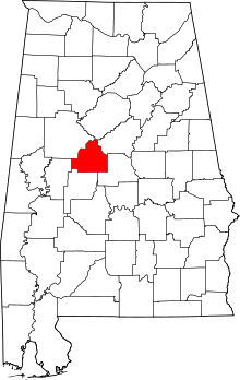 | |
| Towns | ||
| Unincorporated communities | ||
| Ghost town | ||
| Footnotes | ‡This populated place also has portions in an adjacent county or counties | |
This article is issued from
Wikipedia.
The text is licensed under Creative Commons - Attribution - Sharealike.
Additional terms may apply for the media files.