Ramada, California
Coordinates: 39°33′20″N 121°42′40″W / 39.55556°N 121.71111°W
| Ramada | |
|---|---|
| Unincorporated community | |
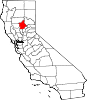
 Ramada Location in California  Ramada Ramada (the US) | |
| Coordinates: 39°33′20″N 121°42′40″W / 39.55556°N 121.71111°W | |
| Country | United States |
| State | California |
| County | Butte County |
| Elevation[1] | 138 ft (42 m) |
Ramada is an unincorporated community in Butte County, California. It is located 9 miles (14 km) west-northwest of Oroville on the Sacramento Northern Railroad,[2] at an elevation of 138 feet (42 m).
References
- ↑ U.S. Geological Survey Geographic Names Information System: Ramada, California
- ↑ Durham, David L. (1998). California's Geographic Names: A Gazetteer of Historic and Modern Names of the State. Clovis, Calif.: Word Dancer Press. p. 297. ISBN 1-884995-14-4.
This article is issued from
Wikipedia.
The text is licensed under Creative Commons - Attribution - Sharealike.
Additional terms may apply for the media files.