Rajapet
| Rajapet | |
|---|---|
| Village | |
 Rajapeta samsthan | |
 Rajapet Location in Telangana, India  Rajapet Rajapet (India) | |
| Coordinates: 17°44′N 78°55′E / 17.733°N 78.917°ECoordinates: 17°44′N 78°55′E / 17.733°N 78.917°E | |
| Country | India |
| State | Telangana |
| District | Bhuvanagiri |
| Area[1][2] | |
| • Total | 7.98 km2 (3.08 sq mi) |
| Population (2011)[1] | |
| • Total | 4,902 |
| • Density | 610/km2 (1,600/sq mi) |
| Languages | |
| • Official | Telugu |
| Time zone | UTC+5:30 (IST) |
| Vehicle registration | 'TS-30' |
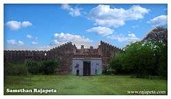
Rajapet is a historic location, popularly known as Samsthan Rajapeta. This town has one of the popular forts of Indian state of Telangana located in Yadadri Bhuvanagiri district.
References
- 1 2 "District Census Handbook - Nalgonda" (PDF). Census of India. p. 13,158. Retrieved 8 February 2016.
- ↑ Samsthan Rajapeta - Website
This article is issued from
Wikipedia.
The text is licensed under Creative Commons - Attribution - Sharealike.
Additional terms may apply for the media files.