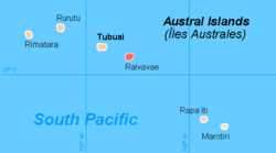
Raivavae
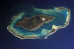 NASA picture of Raivavae island | |
 Raivavae | |
| Geography | |
|---|---|
| Location | Pacific Ocean |
| Coordinates | 23°52′09″S 147°39′49″W / 23.86917°S 147.66361°W |
| Archipelago | Australes |
| Area | 14.95 km2 (5.77 sq mi) |
| Highest elevation | 437 m (1,434 ft) |
| Highest point | Mount Hiro |
| Administration | |
|
France | |
| Overseas collectivity | French Polynesia |
| Administrative subdivision | Australes |
| Commune | Raivavae |
| Demographics | |
| Population | 975[1] (2016) |
| Pop. density | 59 /km2 (153 /sq mi) |
| Raivavae | ||
|---|---|---|
| Commune | ||
| ||
 | ||
| Coordinates: 23°52′09″S 147°39′49″W / 23.869167°S 147.663611°WCoordinates: 23°52′09″S 147°39′49″W / 23.869167°S 147.663611°W | ||
| Country | France | |
| Overseas collectivity | French Polynesia | |
| Area1 | 17.52 km2 (6.76 sq mi) | |
| Population (2016)2 | 977 | |
| • Density | 56/km2 (140/sq mi) | |
| INSEE/Postal code | 98739 /98750 | |
|
1 French Land Register data, which excludes lakes, ponds, glaciers > 1 km2 (0.386 sq mi or 247 acres) and river estuaries. 2 Population without double counting: residents of multiple communes (e.g., students and military personnel) only counted once. | ||

Raivavae is an island that is part of the Austral Islands in French Polynesia.
The main island covers an area of 14.95 km2 (5.77 sq mi) and at the 2016 census had a population of 975. Offshore island of Haamu had a population of 2. Its highest point is the top of an extinct volcano which is 437 metres (1,434 ft) high.
History
The first sighting by Europeans was recorded by the Spanish naval officer Tomás Gayangos on board of the frigate "El Aguila" on 5 February 1775. Gayangos had taken over the command of the expedition of Domingo de Bonechea of 1774 after his death in Tahiti and was returning to the Viceroyalty of Peru.[2] The main source describing this sighting is that of José Andía y Varela, pilot of the packet boat Jupiter that accompanied El Aguila in this return trip. On 6 February a boat was sent in, and made contact with the inhabitants at the shore edge, but landing was not made. Raivavae was charted as Santa Rosa by the Spaniards. The inhabitants said the name of their island was Oraibaba.[3][4][5]
It was annexed by France in 1880.
Administration
The islands of Raivavae are administratively within the commune with the same name. Raivavae consists of the following associated communes:
- Anatonu
- Rairua-Mahanatoa
- Vaiuru
See also
References
- ↑ "Population". Institut de la statistique de la Polynésie française (in French). Retrieved 9 January 2015.
- ↑ Salmond, Anne (2010). Aphrodite's Island. Berkeley: University of California Press. p. 355. ISBN 9780520261143.
- ↑ Andía y Varela, José Relación del viaje hecho a la isla de Amat, por otro nombre Otahiti, y descubrimiento de las islas adyacentes en los años 1774 y 1775, Barcelona, 1947, p.83
- ↑ Sharp, Andrew The discovery of the Pacific Islands Oxford, 1960, p.126,127
- ↑ Corney, Bolton Granvill The quest and occupation of Tahiti by emissaries of Spain during the years 1772-1776, London, 1913, Vol I, p.XLVII
| Wikimedia Commons has media related to Raivavae. |