Rack Marsh
Rack Marsh is a nature reserve on the edge of the hamlet of Bagnor in Berkshire, England.[1] The nature reserve is under the management of the Berkshire, Buckinghamshire and Oxfordshire Wildlife Trust.[2] Part of the reserve is in the Kennet and Lambourn Floodplain, a Biological Site of Special Scientific Interest.[3][4]
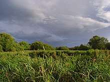
Geography and site
The site is 4 hectares (9.9 acres) in size.[5] Rack Marsh is an old wet meadow.[5] A thick layer of peat has developed on top of the deposits of alluvium and gravel which the river has spread over the chalk.[5]
History
There is evidence of prehistoric activity in the area: a prehistoric canoe was discovered in the layer of peat by some labourers who were digging a ditch to form a boundary of a garden.[6]
In 1996 the discovery of the rare Desmoulin's whorl snail on the reserve meant that the Newbury bypass was almost stopped, but the high court ruled in the developers' favour.[7] The decision to continue with the construction of the road meant that the nature reserve was cut in size, losing half its area.[8]
Fauna
The site has the following fauna:[1][5]
Invertebrates
Birds
Flora
The site has the following flora:[2][5][9]
Plants
References
- 1 2 "Rack Marsh gets an Owl Box | the Natureheads blog". Natureheads.wordpress.com. 2009-10-05. Retrieved 2017-04-15.
- 1 2 "THE WALKER'S GUIDE : DONNINGTON, SNELSMORE & BAGNOR" (PDF). North Wessex Downs. Retrieved 2017-04-15.
- ↑ Department of the Official Report (Hansard), House of Commons, Westminster. "House of Commons Hansard Written Answers for 6 Jun 1996 (pt 2)". Publications.parliament.uk. Retrieved 2017-04-15.
- ↑ "Magic Map Application". Magic.defra.gov.uk. Retrieved 2017-04-15.
- 1 2 3 4 5 Opening Times. "Rack Marsh | Berks, Bucks & Oxon Wildlife Trust". Bbowt.org.uk. Retrieved 2017-04-15.
- ↑ "The History and Antiquities of Newbury and Its Environs: Including Twenty ... - Google Books". Books.google.co.uk. Retrieved 2017-04-15.
- ↑ Matt Weaver and agencies. "End of the road for protected snail | Environment". The Guardian. Retrieved 2017-04-15.
- ↑ "The Newbury bypass 20 years on: A road to environmental ruin or recovery? | Berks, Bucks & Oxon Wildlife Trust". Bbowt.org.uk. 2016-04-01. Retrieved 2017-04-15.
- ↑ "SITE NAME: KENNET AND LAMBOURN FLOODPLAIN" (PDF). Retrieved 2017-04-15.