Rablay-sur-Layon
| Rablay-sur-Layon | |
|---|---|
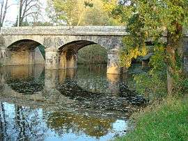 The Layon at Rablay-sur-Layon | |
 Rablay-sur-Layon Location within Pays de la Loire region  Rablay-sur-Layon | |
| Coordinates: 47°17′45″N 0°34′31″W / 47.2958°N 0.5753°WCoordinates: 47°17′45″N 0°34′31″W / 47.2958°N 0.5753°W | |
| Country | France |
| Region | Pays de la Loire |
| Department | Maine-et-Loire |
| Arrondissement | Angers |
| Canton | Chemillé-Melay |
| Area1 | 7.44 km2 (2.87 sq mi) |
| Population (2005)2 | 703 |
| • Density | 94/km2 (240/sq mi) |
| Demonym(s) |
Rablayen(s) (/Template:APIb) et Rablayenne(s) (/Template:APIb/) |
| Time zone | UTC+1 (CET) |
| • Summer (DST) | UTC+2 (CEST) |
| INSEE/Postal code | 49256 /49750 |
| Elevation | 20–89 m (66–292 ft) |
| Website | Site officiel de la commune de Rablay-sur-Layon |
|
1 French Land Register data, which excludes lakes, ponds, glaciers > 1 km2 (0.386 sq mi or 247 acres) and river estuaries. 2 Population without double counting: residents of multiple communes (e.g., students and military personnel) only counted once. | |
Rablay-sur-Layon (/ra.blε.syr.lε.jɔ̃/) is a former commune in the Maine-et-Loire department in western France. On 1 January 2016, it was merged into the new commune of Bellevigne-en-Layon.[1]
Geography
The commune is traversed by the river Layon.
See also
| Wikimedia Commons has media related to Rablay-sur-Layon. |
References
- ↑ Arrêté préfectoral Archived 2016-02-15 at the Wayback Machine. 2 November 2015
This article is issued from
Wikipedia.
The text is licensed under Creative Commons - Attribution - Sharealike.
Additional terms may apply for the media files.