RCAF Station High River
| RCAF Station High River | |||||||||||
|---|---|---|---|---|---|---|---|---|---|---|---|
|
=High River, Alberta, Canada Near High River, Alberta in Canada | |||||||||||
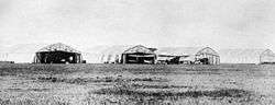 DH4 aircraft at the High River Air Station, 1922 | |||||||||||
 RCAF Station High River | |||||||||||
| Coordinates | 50°35′35″N 113°50′30″W / 50.59306°N 113.84167°WCoordinates: 50°35′35″N 113°50′30″W / 50.59306°N 113.84167°W | ||||||||||
| Site information | |||||||||||
| Owner | Dept of National Defence (Canada) | ||||||||||
| Site history | |||||||||||
| In use | 1921-1944 | ||||||||||
| Airfield information | |||||||||||
| Elevation | 3,400 feet (1,036 m)[1] AMSL | ||||||||||
| |||||||||||
| Airfields | |||||||||||
RCAF Station High River was a station of the Royal Canadian Air Force (RCAF) located at High River, Alberta, Canada.
High River Air Station
The Canadian Air Board began operating the High River Air Station in January 1921 after having moved the station from Morley, Alberta, where the weather was discovered to be too erratic and dangerous for flying. In the early days, the station had an entirely civil function and was the largest in Canada with ten war-surplus aircraft that were part of the Imperial Gift provided to Canada by Britain after the First World War. In late 1922 when the Air Board and the fledgling Canadian Air Force was reorganized, operations at High River became the responsibility of the Canadian Air Force. And when the Royal Canadian Air Force was formed in 1924, the station became a Royal Canadian Air Force station: RCAF Station High River.
Most of the flying operations consisted of fire-spotting forestry patrols over the mountains and foothills to the west, which were flown by No. 2 (Operations) Squadron.[2] The aircraft used was the DH.4. Late in 1924 Avro Vipers began to be used, and in 1928 De Havilland Cirrus 60 Moths were added. Initially, two patrols were made daily, to the Clearwater, Bow and Crowsnest Forest Reserves. One patrol flew north as far as the Clearwater River, and one south to the International Boundary. Eventually substations were built at Pincher Creek in the south and Eckville in the north to increase patrol efficiency. In 1928, a substation was constructed at Grande Prairie to enable the patrolling of the Peace River Country. Of the early Canadian air stations, High River was the most active, with 215 flights flown on forest patrols.[3]
Other responsibilities of the station included aerial photography, parachute experimentation, aircraft testing, and aerial pesticide spraying. In the early 1920s the station became involved with experimenting with radio. Wireless equipment was developed in cooperation with the Canadian Corps of Signals to develop radio signals to be broadcast over distances greater than 300 km.[4] The most powerful radio transmitter in North America began operating from the High River Air Station in 1922.[5]
After jurisdiction for natural resource management was transferred to the Province of Alberta in 1930, fire towers were built and spotting aircraft were no longer necessary. Fire-spotting patrols gradually ceased. Other activities such as aircraft testing continued until the station closed on March 31, 1931. The station did, however, remain as an aircraft storage facility until the beginning of the Second World War when the station was reactivated to train pilots for wartime service.
No. 5 Elementary Flying Training School
RCAF Station High River was a major participant in British Commonwealth Air Training Plan aircrew training during the war. No. 5 Elementary Flying Training School (EFTS) was established at High River in 1941 using civilian instructors from the Calgary Aero Club. De Havilland Tiger Moths were the first aircraft used. They were later replaced by Fairchild Cornells. An unprepared emergency and practice landing field, also known as a relief landing field, was located on the then dry lakebed of nearby Frank Lake.[6]
Aerodrome
In approximately 1942 the aerodrome was listed at 50°36′N 113°51′W / 50.600°N 113.850°W with a Var. 23 degrees E and elevation of 3,400 feet (1,036 m). The field was listed as "Irregular all-way turf field" and had three runways listed as follows:[1]
| Runway Name | Length | Width | Surface |
|---|---|---|---|
| 7/25 | 3,100 feet (945 m) | 1,000 feet (305 m) | Turf |
| 8/26 | 3,100 feet (945 m) | 1,000 feet (305 m) | Turf |
| 14/32 | 4,000 feet (1,219 m) | 1,000 feet (305 m) | Turf |
Relief landing field - Frank Lake
In approximately 1942 the relief aerodrome was listed at 50°33′N 113°43′W / 50.550°N 113.717°W with a Var. 23 degrees E and elevation of 3,295 feet (1,004 m). The field was listed as "Dry Lake Bed" and was located at Frank Lake, east of High River, and was marked as a square measuring:
- N-S - 2,640 feet (805 m)
- E-W - 2,640 feet (805 m) [7]
Closure to present
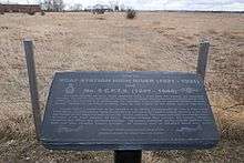
The High River aerodrome closed in December 1944. The site is no longer a functioning airport and is used for private commercial purposes. It should not be confused with the present High River Airport, which is in a different location.
References
- Hatch, F.J. Aerodrome of Democracy: Canada and the British Commonwealth Air Training Plan 1939–1945. Ottawa: Canadian Department of National Defence, 1983. ISBN 0-660-11443-7. Retrieved 2010-04-26.
- Milberry, Larry (General Editor). Sixty Years - The RCAF and CF Air Command 1924 - 1984. Toronto: Canav Books, 1984. ISBN 0-9690703-4-9.
- Roberts, Leslie. There Shall Be Wings. Toronto: Clark, Irwin and Co. Ltd., 1959. No ISBN.
- Fencelines and Furrows Historical Book Society. Fencelines and Furrows. First Edition, 1969. No ISBN. Retrieved 2018-07-10
- Bruce Forsyth's Canadian Military History Page - Abandoned Bases (Alberta): No. 5 Elementary Flying Training School Retrieved 2014-05-23
- Smith, D. Those Magnificent Men in Their Flying Machines, Aerial Reconnaissance in the Canadian Rockies During the 1920s. Western Division, Canadian Association of Geographers. Western Geography 7 (1997) Retrieved 2016-04-07
- The High River Air Station and No. 5 Elementary Flying Training School Retrieved 2016-04-07
- Staff writer (c. 1942). Pilots Handbook of Aerodromes and Seaplane Bases Vol. 2. Royal Canadian Air Force.