RCAF Station Claresholm
| RCAF Station Claresholm | |||||||||||||||||
|---|---|---|---|---|---|---|---|---|---|---|---|---|---|---|---|---|---|
| Claresholm, Alberta in Canada | |||||||||||||||||
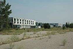 RCAF Station Claresholm hangars in 2006 | |||||||||||||||||
 RCAF Station Claresholm Location in Alberta | |||||||||||||||||
| Coordinates | 50°00′17″N 113°37′48″W / 50.00472°N 113.63000°WCoordinates: 50°00′17″N 113°37′48″W / 50.00472°N 113.63000°W | ||||||||||||||||
| Site information | |||||||||||||||||
| Owner | Royal Canadian Air Force | ||||||||||||||||
| Site history | |||||||||||||||||
| Built | June 9, 1941 | ||||||||||||||||
| In use | 1958 | ||||||||||||||||
| Fate | Became Claresholm Industrial Airport | ||||||||||||||||
| Airfield information | |||||||||||||||||
| Elevation | 2,950 feet (899 m)[1] AMSL | ||||||||||||||||
| |||||||||||||||||
| Airfields | |||||||||||||||||
RCAF Station Claresholm was initially a British Commonwealth Air Training Plan station that trained pilots for World War II service. The station was located near Claresholm, Alberta, Canada.
History
World War II
No. 15 Service Flying Training School (SFTS) was opened on 9 June 1941, and closed on 30 March 1945.[2] Ansons and Cessna Cranes were the aircraft used, and its relief airfields were RCAF Woodhouse, a few kilometers east at 49°59′24″N 113°26′51″W / 49.99000°N 113.44750°W, and RCAF Pulteney, a few kilometers north.
No. 2 Flying Instructor School (FIS) opened in April 1942 but closed September 1942 and moved to Vulcan. Student pilots at No.2 FIS flew Tiger Moths and Cessna Cranes.
Aerodrome Information
In approximately 1942 the aerodrome was listed at 50°00′N 113°38′W / 50.000°N 113.633°W with a Var. 23 degrees E and elevation of 3,325 feet (1,013 m). Six runways were listed as follows:
| Runway Name | Length | Width | Surface |
|---|---|---|---|
| 2/20 | 3,000 feet (914 m) | 100 feet (30 m) | Hard surfaced |
| 2/20 | 3,100 feet (945 m) | 100 feet (30 m) | Hard surfaced |
| 14/32 | 3,100 feet (945 m) | 100 feet (30 m) | Hard surfaced |
| 14/32 | 3,100 feet (945 m) | 100 feet (30 m) | Hard surfaced |
| 8/26 | 3,000 feet (914 m) | 100 feet (30 m) | Hard surfaced |
| 8/26 | 3,200 feet (975 m) | 100 feet (30 m) | Hard surfaced |
Relief landing field – Woodhouse
The primary Relief Landing Field (R1) for RCAF Station Claresholm was located southeast of the community of Claresholm. In approximately 1942 the aerodrome was listed at 50°00′N 113°27′W / 50.000°N 113.450°W with a Var. 23 degrees E and elevation of 3,300 feet (1,006 m). Three runways were listed as follows:
| Runway Name | Length | Width | Surface |
|---|---|---|---|
| 2/20 | 3,020 feet (920 m) | 100 feet (30 m) | Hard surfaced |
| 14/32 | 3,020 feet (920 m) | 100 feet (30 m) | Hard surfaced |
| 8/26 | 3,020 feet (920 m) | 100 feet (30 m) | Hard surfaced |
Postwar
Claresholm was placed on care and maintenance status until reactivated in 1951 as a NATO training centre run by No. 3 Flying Training School (flying Harvards). The station closed again in 1958 when the school was relocated to Gimli, Manitoba. It is now the Claresholm Industrial Airport. As of August 2011, hangars 2 to 4 are derelict and deteriorating.
References
- 1 2 3 4 5 6 7 8 Staff writer (c. 1942). Pilots Handbook of Aerodromes and Seaplane Bases Vol. 2. Royal Canadian Air Force. p. 86.
- ↑ Hatch, F. J. (1983). The Aerodrome of Democracy: Canada and the British Commonwealth Air Training Plan, 1939-1945. Ottawa: Directorate of History, Department of National Defence. ISBN 0660114437.
- ↑ Staff writer (c. 1942). Pilots Handbook of Aerodromes and Seaplane Bases Vol. 2. Royal Canadian Air Force. p. 118.