RAF Stradishall
| RAF Stradishall | |||||||||||||||||||
|---|---|---|---|---|---|---|---|---|---|---|---|---|---|---|---|---|---|---|---|
 Latin: Vires de caelo ("Might from the sky") | |||||||||||||||||||
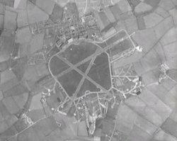 Aerial view in 1945 | |||||||||||||||||||
| Summary | |||||||||||||||||||
| Airport type | Military | ||||||||||||||||||
| Owner | Ministry of Defence | ||||||||||||||||||
| Operator | Royal Air Force | ||||||||||||||||||
| Location | Stradishall, Suffolk | ||||||||||||||||||
| Built | 1937 | ||||||||||||||||||
| In use | 1938-1970 | ||||||||||||||||||
| Elevation AMSL | 381 ft / 116 m | ||||||||||||||||||
| Coordinates | 52°08′06″N 000°30′51″E / 52.13500°N 0.51417°ECoordinates: 52°08′06″N 000°30′51″E / 52.13500°N 0.51417°E | ||||||||||||||||||
| Map | |||||||||||||||||||
 RAF Stradishall Location in Suffolk | |||||||||||||||||||
| Runways | |||||||||||||||||||
| |||||||||||||||||||
Royal Air Force Stradishall or more simply RAF Stradishall is a former Royal Air Force station located 4.7 miles (7.6 km) north east of Haverhill, Suffolk and 9 miles (14 km) south west of Bury St Edmunds, Suffolk, England.
History
The airfield was home to a number of squadrons during its lifetime:
- No. 1 Squadron RAF,[1] No. 9 Squadron RAF,[2] No. 35 Squadron RAF,[3] No. 51 Squadron RAF,[4] No. 54 Squadron RAF,[5] No. 75 Squadron RAF,[6] No. 85 Squadron RAF,[7] No. 89 Squadron RAF.[7]
- No. 101 Squadron RAF,[8] No. 109 Squadron RAF,[9] No. 115 Squadron RAF,[10] No. 125 Squadron RAF,[11] No. 138 Squadron RAF,[12] No. 148 Squadron RAF,[13] No. 149 Squadron RAF,[13] No. 150 Squadron RAF,[13] No. 152 Squadron RAF,[14] No. 158 Squadron RAF,[14] No. 186 Squadron RAF.[15]
- No. 207 Squadron RAF,[16] No. 208 Squadron RAF,[16] No. 214 Squadron RAF,[17] No. 215 Squadron RAF,[17] No. 236 Squadron RAF,[18] No. 245 Squadron RAF,[19] No. 254 Squadron RAF,[20] No. 263 Squadron RAF.[21]
- No. 311 Squadron RAF.[22]
Current use
The airfield closed in 1970 and is now the site of two category C prisons: HMP Highpoint North and HMP Highpoint South. Part of the former airfield remains a Ministry of Defence training site which is not accessible to the public.
The airfield has been sold to a private buyer to be converted into farm land and is out of bounds to the public.
There is a memorial to RAF Stradishall outside Stirling House which was once part of the officers quarters and is now a training unit for the Prison service.
References
Citations
- ↑ Jefford 1988, p. 23.
- ↑ Jefford 1988, p. 27.
- ↑ Jefford 1988, p. 37.
- ↑ Jefford 1988, p. 41.
- ↑ Jefford 1988, p. 42.
- ↑ Jefford 1988, p. 48.
- 1 2 Jefford 1988, p. 51.
- ↑ Jefford 1988, p. 54.
- ↑ Jefford 1988, p. 55.
- ↑ Jefford 1988, p. 57.
- ↑ Jefford 1988, p. 58.
- ↑ Jefford 1988, p. 60.
- 1 2 3 Jefford 1988, p. 62.
- 1 2 Jefford 1988, p. 63.
- ↑ Jefford 1988, p. 66.
- 1 2 Jefford 1988, p. 69.
- 1 2 Jefford 1988, p. 71.
- ↑ Jefford 1988, p. 75.
- ↑ Jefford 1988, p. 77.
- ↑ Jefford 1988, p. 79.
- ↑ Jefford 1988, p. 80.
- ↑ Jefford 1988, p. 85.
Bibliography
External links
| Wikimedia Commons has media related to RAF Stradishall. |
Royal Air Force portal | ||
| Formations and units |  | |
| Branches and components | ||
| Reserve forces | ||
| Associated civil organisations | ||
| Equipment | ||
| Personnel | ||
| Appointments | ||
| Symbols and uniform | ||