RRH Benbecula
| RRH Benbecula | |
|---|---|
| North Uist, Outer Hebrides in Scotland | |
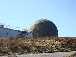 Radar dome at RRH Benbecula | |
|
| |
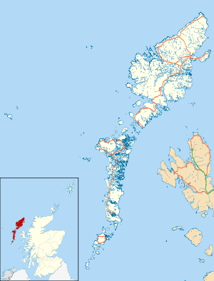 RRH Benbecula Shown within the Outer Hebrides | |
| Coordinates | 57°37′02″N 007°26′46″W / 57.61722°N 7.44611°WCoordinates: 57°37′02″N 007°26′46″W / 57.61722°N 7.44611°W |
| Type | Remote Radar Head |
| Site information | |
| Owner | Ministry of Defence |
| Operator | Royal Air Force |
| Controlled by | No. 1 Group (Air Combat) |
| Radar type | Lockheed Martin AN/TPS-77 |
| Site history | |
| Built | 1980 |
| In use | 1980-Present |
| Garrison information | |
| Occupants | Radar Flight (North) |
Remote Radar Head Benbecula or RRH Benbecula, is an air defence radar station operated by the Royal Air Force. It is located at Cleitreabhal a'Deas, 17 kilometres (11 mi) from Lochmaddy on North Uist in the Outer Hebrides of Scotland.
The radar site was previously known as RAF Benbecula, the name having previously been associated with an RAF airfield on the island and a nearby weapons testing range, which is now known as MOD Hebrides.
History
Early years
An airfield has existed on Benbecula since 1936 when Scottish Airways began operating to what was known as Balivanich Airfield, located on the north west corner of the island.[1]
RAF Benbecula
Airfield
Between 1941 and 1942, during the Second World War, the airfield became RAF Benbecula, when it came under the control of the Royal Air Force's Coastal Command. During this period it was home to aircraft carrying out patrols in the Atlantic, protecting shipping convoys from German U-Boats.[1] Such missions were carried out by the Lockheed Hudson and latterly the Boeing B-17 Flying Fortress and Vickers Wellington.[2]
It later became the control centre for the nearby Hebrides Rocket Range.[1]
At its peak, RAF Benbecula had several thousand troops stationed at the station and at several other sites around the islands.
The following units were based at the airfield at some point:
- No. 36 Squadron RAF.[3]
- No. 179 Squadron RAF.[4]
- No. 206 Squadron RAF.[5]
- No. 220 Squadron RAF.[6]
- No. 304 Squadron RAF.[7]
- No. 455 Squadron RAF.[8]
After the Second World War, the airfield became Benbecula Airport, a civilian airport serving the Outer Hebrides.
Radar station
Although now a civilian airfield, a military presence remained and the RAF Benbecula name continued when a radar station was established.[9] A control and reporting centre, part of the UK Air Surveillance And Control System (ASACS), was constructed at the airfield which linked it to RAF Buchan in Aberdeenshire.
The station was downgraded in the late 1990s to a remote radar head and the RAF pulled-out of the main airfield site at Benbecula. Initially under the command and control of RAF Buchan, responsibility was transferred to RAF Boulmer in Northumberland in September 2004.[10]
Benbecula operated several radar types until the Type 92 (more widely known out-with RAF service as the Lockheed Martin AN/FPS-117 ) came into service in the 1980s. The Type 92 was replaced in 2015 with a new Lockheed Martin AN/TPS-77 system. The new radar was funded by wind farm developers and was installed in order to help reduce the impact of interference from wind turbines.[11][12][10]
Weapons range
The British Army also had a large presence in the Outer Hebrides, operating an artillery range on South Uist. This role was passed to the Defence Evaluation and Research Agency (eventually to become QinetiQ), who remain at the Benbecula and South Uist sites, collectively known as MOD Hebrides.[13]
Operations
The radar collects data as part of the UK Air Surveillance And Control System (ASACS) based at RAF Boulmer. From there the station is monitored and controlled to support the creation of the recognised air picture for the United Kingdom.[12][14] The radar site also accommodates several types of VHF and UHF ground-to-air transmitters.
Radar Flight (North) of the ASACS Engineering & Logistics Squadron based at RAF Boulmer has command and control of RRH Buchan and ensures its operational availability.[14]
See also
References
Citations
- 1 2 3 "About Us - Benbecula Airport". Highlands and Islands Airports Limited. Retrieved 23 October 2017.
- ↑ "Marking the 75th anniversary of Western Isles air bases". Stornoway Gazette. 27 March 2016. Retrieved 23 October 2017.
- ↑ Jefford 1988, p. 37.
- ↑ Jefford 1988, p. 65.
- ↑ Jefford 1988, p. 69.
- ↑ Jefford 1988, p. 72.
- ↑ Jefford 1988, p. 85.
- ↑ Jefford 1988, p. 93.
- ↑ "Benbecula Airport, Airfield". Canmore - National Record of the Historic Environment. Retrieved 23 October 2017.
- 1 2 "RAF Boulmer". Royal Air Force. Retrieved 2009-08-22.
- ↑ "Minutes of the Aviation Management Board Meeting - 17 July 2015" (PDF). GOV.UK. 17 July 2015. Retrieved 6 August 2017.
- 1 2 Sudbry, Amy (24 February 2014). "MOD radar upgrades: Buchan and Benbecula". Pager Power. Retrieved 6 August 2017.
- ↑ "MOD Hebrides". LTPA. Qinetiq. Retrieved 23 October 2017.
- 1 2 "Radar Flight North". RAF Boulmer. Retrieved 6 August 2017.
Bibliography
External links
Royal Air Force portal | ||
| Formations and units |  | |
| Branches and components | ||
| Reserve forces | ||
| Associated civil organisations | ||
| Equipment | ||
| Personnel | ||
| Appointments | ||
| Symbols and uniform | ||