Downtown Tijuana
| Downtown Tijuana | |
|---|---|
| Neighborhood of Tijuana | |
| Colonia Zona Centro | |
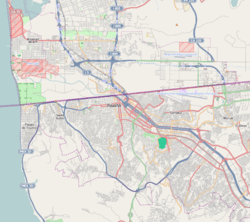 Downtown Tijuana Location within Central Tijuana | |
| Coordinates: 32°32′20″N 117°02′44″W / 32.538876°N 117.045572°WCoordinates: 32°32′20″N 117°02′44″W / 32.538876°N 117.045572°W | |
| Country | United Mexican States |
| State | Baja California |
| Municipality (municipio) | Tijuana |
| Borough (delegación) | Centro |
| ZIP Code | 22000 |
| Area code(s) | 664 |
Downtown Tijuana, officially Colonia Zona Centro, is an official neighborhood of Tijuana, Mexico. It is located within the Central Borough ("Delegación Centro") of the city, immediately southwest of the San Ysidro Port of Entry. It is bordered by Calle Artículo 123 and the Zona Norte neighborhood (and red light district) on the north, by Calle Ocampo and Zona Este and Zona Río on the east, and by the colonias (neighborhoods) Castillo, Lindavista, Altamira, Independencia, Morelos, and Juárez on the west and south.[1] Avenida Revolución is the main tourist thoroughfare while Avenida Constitución is a main traditional shopping thoroughfare.
References
This article is issued from
Wikipedia.
The text is licensed under Creative Commons - Attribution - Sharealike.
Additional terms may apply for the media files.