Bucaná River
| Bucaná River | |
|---|---|
| Country | Puerto Rico |
| Location | Ponce |
| Physical characteristics | |
| Main source |
Barrio Machuelo Arriba 115 feet (35 m)[1] |
| River mouth |
Caribbean Sea 0 feet (0 m) (Caribbean Sea) |
| Length | 5.69 miles (9.16 km)[2][3] |
| Basin features | |
| Progression |
Machuelo Abajo Sabanetas Bucana |
| River system | Río Bucaná |
| Basin size | 28.45 sq mi (73.7 km2)[4][5] |
| Tributaries |
|
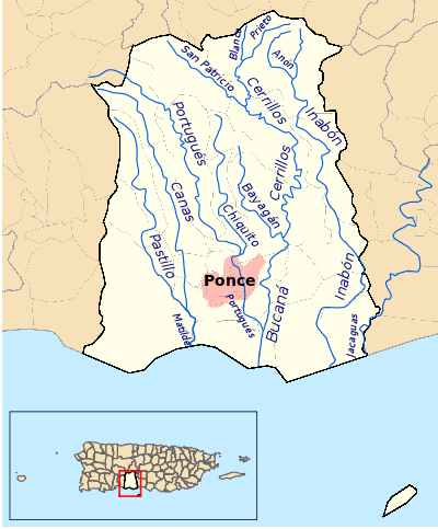
Bucaná River (Spanish: Río Bucaná) is a river in the municipality of Ponce, Puerto Rico. Río Bucaná has its origin in barrio Machuelo Arriba where it forms at an altitude of 115 feet (35 m). It forms from the confluence of Río Cerrillos and Río Bayagán.[8][note a] It is also fed by Río Portugues during its southernly run. Río Bucaná used to run for some 29.5 kilometers (18.3 mi)[9] prior to canalization and other diversion work by the U.S. Army Corps of Engineers. It now runs for 5.89 miles (9.48 km) to drain into the Caribbean Sea. This river is one of the 14 rivers in the municipality.
Tributaries
Bucaná River is formed in barrio Machuelo Arriba by the confluence of the Bayagán and Cerrillos rivers.[10] It has two tributaries, Río Portugues and Río Cerrillos.
Course
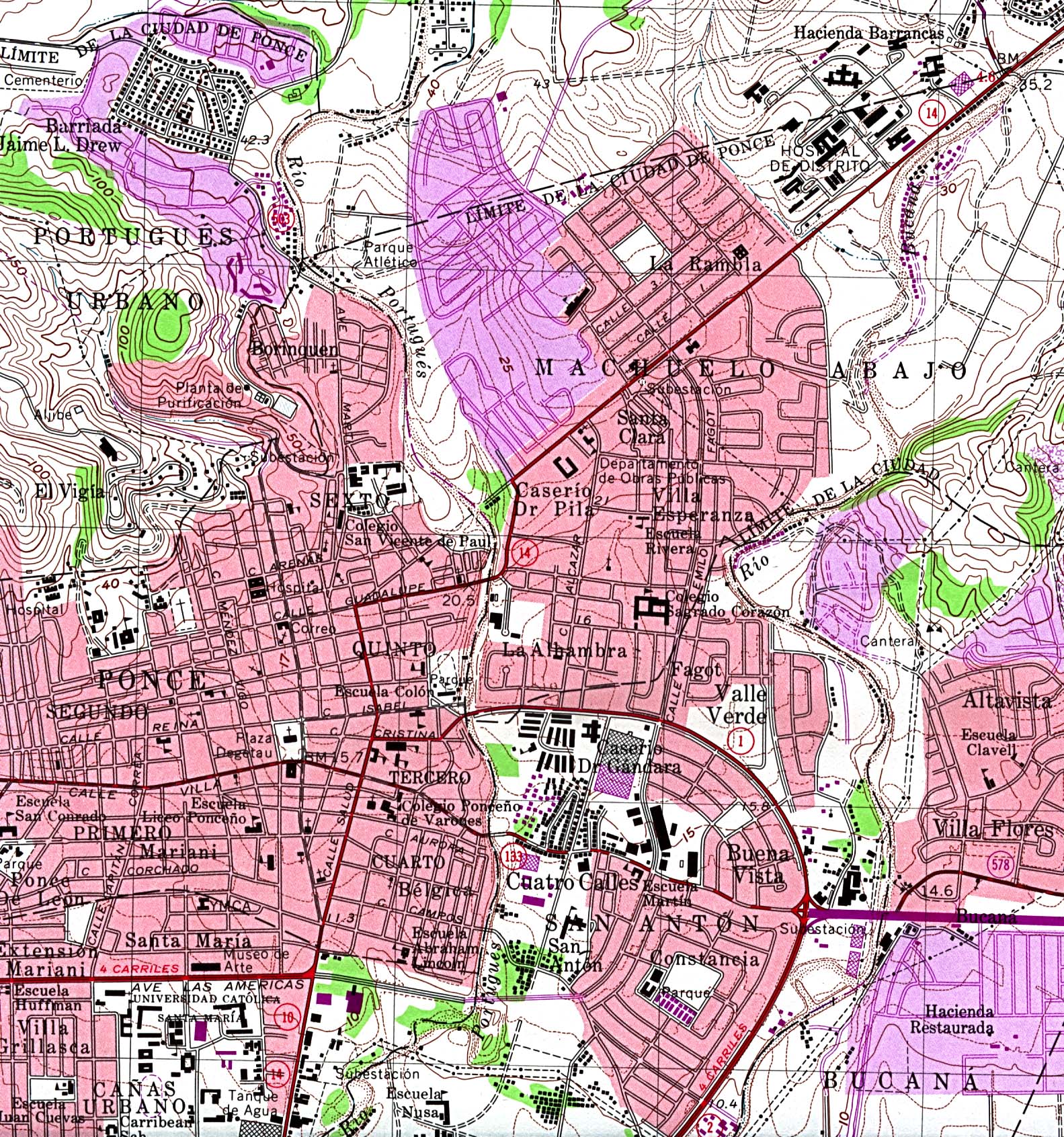
Río Bucaná originates in Cordillera Central at Monte Jayuya and runs in a winding fashion to the south receiving feeds from Rio Jauca, Rio Bayagan and Quebrada Guayo.[11] Río Bucaná is channalized from the point it enters the city of Ponce and until it is fed by Rio Portugues (also channalized) in Barrio Bucaná at the southern tip of Julio Enrique Monagas Family Park.[12] The river empties into the Caribbean Sea near La Guancha. A section of the river used to run alongside Route 14, near the former Hospital de Distrito (now Hospital San Lucas), but it has since been diverted.[13]
Uses
Río Bucaná is largely used for irrigation of crops on the southern plains of Puerto Rico located east of the city of Ponce.[14]
Notes
- 1.^ One reliable source, (Puerto Rico Department of Environmental Resources)[15] dated February 2007, states that this river forms from the confluence of Río Cerrillos and Río Bayagán. However, another reliable source, (Puerto Rico Office of Management and Budget)[16] not dated but using data with dates that fluctuate between 2001 and 2010, shows the river forms from various minor streams, and that Río Cerrillos is a feeder river to Río Bucaná. In this article we are using the first source as the most reliable. Still, given that the U.S. Corps of Engineers has been working in redirecting and canalizing Río Bucaná, the reader is advised that the actual origin of the current river may be one of the two stated above or may well be different yet.
See also
Coordinates: 17°58′07″N 66°36′00″W / 17.9685786°N 66.5998946°W[17]
References
- ↑ Maptest. Archived February 18, 2010, at the Wayback Machine. Government of the Commonwealth of Puerto Rico. General Purpose Population Data, Census 2000. Unidad de Sistemas de Información Geográfica, Área de Tecnología de Información Gubernamental, Oficina de Gerencia y Presupuesto. Gobierno de Puerto Rico. Retrieved 24 October 2011.
- ↑ Los Rios. Archived 2012-04-01 at the Wayback Machine. Hojas de Nuestro Ambiente. February 2007: P013. Page 2. Puerto Rico Department of Natural and Environmental Resources. Retrieved 30 October 2011.
- ↑ Recursos de Agua de Puerto Rico. Ferdinand Quiñones. 2018. Page 3-7. Accessed 3 October 2018.
- ↑ Maptest. Archived February 18, 2010, at the Wayback Machine. Government of the Commonwealth of Puerto Rico. General Purpose Population Data, Census 2000. Unidad de Sistemas de Información Geográfica, Área de Tecnología de Información Gubernamental, Oficina de Gerencia y Presupuesto. Gobierno de Puerto Rico. Retrieved 25 November 2011.
- ↑ Maptest. Archived February 18, 2010, at the Wayback Machine. Government of the Commonwealth of Puerto Rico. General Purpose Population Data, Census 2000. Unidad de Sistemas de Información Geográfica, Área de Tecnología de Información Gubernamental, Oficina de Gerencia y Presupuesto. Gobierno de Puerto Rico. Retrieved 25 November 2011.
- ↑ Los Rios. Archived 2012-04-01 at the Wayback Machine. Hojas de Nuestro Ambiente. February 2007: P013. Page 2. Puerto Rico Department of Natural and Environmental Resources. Retrieved 30 October 2011.
- ↑ Projecto Salon Hogar (Estudios Sociales, Puerto Rico, Ponce, Hidrografia). Retrieved 30 October 2011.
- ↑ Projecto Salon Hogar (Estudios Sociales, Puerto Rico, Ponce, Hidrografia). Retrieved August 8, 2009.
- ↑ Government of the Municipality of Ponce. Periodico "El Señorial". Special issue: Carnaval Ponceño 2013. February 2013. Page 17. Ponce, Puerto Rico.
- ↑ The Rivers of Puerto Rico.
- ↑ Topographic Map of the City of Ponce.U.S. Geological Survey. 1970. Photorevised 1982. University of Texas Library. Map of old route of river by Route 14/Hospital Distrito. Retrieved November 27, 2009.
- ↑ SAURI v. SAURI.(LEAGLE: Debate Cases, Regulations, Statutes, and More) 45 F.2d 90 (1930). United States Circuit Court of Appeals, First Circuit. 26 November 1930. Retrieved 23 October 2011.
- ↑ Los Rios. Archived 2012-04-01 at the Wayback Machine. Hojas de Nuestro Ambiente. February 2007: P013. Page 2. Puerto Rico Department of Natural and Environmental Resources. Retrieved 30 October 2011.
- ↑ Maptest. Archived February 18, 2010, at the Wayback Machine. Government of the Commonwealth of Puerto Rico. General Purpose Population Data, Census 2000. Unidad de Sistemas de Información Geográfica, Área de Tecnología de Información Gubernamental, Oficina de Gerencia y Presupuesto. Gobierno de Puerto Rico. Retrieved 24 October 2011.
- ↑ U.S. Geological Survey Geographic Names Information System: Río Bucaná
External links
- USGS Hydrologic Unit Map – Caribbean Region (1974)
- Rivers of Puerto Rico
- USGS Maps of Municipality of Ponce Rivers, showing Rio Bucana and others