Bayagán River
| Bayagán River | |
|---|---|
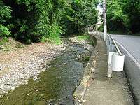 Bayagan River running alongside PR-505 in Barrio Machuelo Arriba, Ponce, Puerto Rico | |
| Country | Puerto Rico |
| Location | Ponce, Puerto Rico |
| Physical characteristics | |
| Main source |
Barrio Montes Llanos 1,650 feet (500 m)(intermittent)[1] 141 feet (43 m) (perennial)[2] |
| River mouth |
Rio Cerrillos, Barrio Machuelo Arriba 42 feet (13 m)[3] |
| Length | 9 km (5.6 mi)[4] |
| Basin features | |
| Progression |
Barrio Montes Llanos, barrio Machuelo Arriba |
| River system | Río Bucaná |
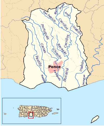
Bayagán River (Spanish: Río Bayagán) is a river in the municipality of Ponce, Puerto Rico. Bayagán is a tributary of Cerrillos River. It has a length of approximately six kilometers and generally runs south. It originates in barrio Montes Llanos and runs south through barrio Machuelo Arriba for about nine kilometers until it meets Río Cerrillos. It is part of the Bucaná River watershed. This river is one of the 14 rivers in the municipality.
Origin
Bayagán River has its origin in Montes Llanos,[5] in an area about two kilometers northwest of Pico Pinto (English: Pinto Peak). This river extends from the mountains in Montes Llanos and gathers waters from the streams in the vicinity of 18.08908 North and 66.61629 West, in the area of Hacienda Usera.
Course and extension
Bayagán River progresses in a southernly direction through barrio Machuelo Arriba until its mouth at coordinates 18.043575 North and 66.585728 West just west of Urbanizacion Valle Alto in the city of Ponce. At that point it feeds into Cerrillos River, at an altitude of 42 feet. Cerrillos will in turn feed into Río Bucaná further downstream, with the latter emptying into the Caribbean Sea about eight kilometers further downstream.[6]
Length and type
Bayagán is only six kilometers long. However, the river is mostly an intermittent river, being perennial only about half a kilometer of its final course.[7] Like several other rivers in southern Puerto Rico, Río Bayagán flows perennially only during the rainy season.[8]
See also
Coordinates: 18°02′37″N 66°35′09″W / 18.0435751°N 66.5857282°W[9]
References
- ↑ Maptest. Archived 2010-02-18 at the Wayback Machine. Government of the Commonwealth of Puerto Rico. General Purpose Population Data, Census 2000. Unidad de Sistemas de Información Geográfica, Área de Tecnología de Información Gubernamental, Oficina de Gerencia y Presupuesto. Gobierno de Puerto Rico. Retrieved 24 October 2011.
- ↑ Feature Query Results. US Geological Survey. Feature ID 1612432. Retrieved 24 October 2011.
- ↑ Maptest. Archived 2010-02-18 at the Wayback Machine. Government of the Commonwealth of Puerto Rico. General Purpose Population Data, Census 2000. Unidad de Sistemas de Información Geográfica, Área de Tecnología de Información Gubernamental, Oficina de Gerencia y Presupuesto. Gobierno de Puerto Rico. Retrieved 24 October 2011.
- ↑ Maptest. Archived 2010-02-18 at the Wayback Machine. Government of the Commonwealth of Puerto Rico. General Purpose Population Data, Census 2000. Unidad de Sistemas de Información Geográfica, Área de Tecnología de Información Gubernamental, Oficina de Gerencia y Presupuesto. Gobierno de Puerto Rico. Retrieved 24 October 2011.
- ↑ Government of the Autonomous Municipality of Ponce. Recursos Naturales. Ponce Ciudad Señorial. Archived 2010-11-21 at the Wayback Machine.
- ↑ Hacienda Usera, Monte Llano Barrio, Ponce Municipio, Puerto Rico. Retrieved 9 October 2011.
- ↑ Maptest. Archived 2010-02-18 at the Wayback Machine. Government of the Commonwealth of Puerto Rico. General Purpose Population Data, Census 2000. Unidad de Sistemas de Información Geográfica, Área de Tecnología de Información Gubernamental, Oficina de Gerencia y Presupuesto. Gobierno de Puerto Rico. Retrieved 24 October 2011.
- ↑ Los Rios. Archived 2012-04-01 at the Wayback Machine. Hojas de Nuestro Ambiente. February 2007: P013. Page 1. Puerto Rico Department of Natural and Environmental Resources. Retrieved 30 October 2011.
- ↑ U.S. Geological Survey Geographic Names Information System: Río Bayagán
External links
- USGS Hydrologic Unit Map – Caribbean Region (1974)