Qusar District
| Qusar Lezgian: КцIар район | |
|---|---|
| Rayon | |
| Azerbaijani: Qusar rayonu | |
.svg.png) Map of Azerbaijan showing Qusar Rayon | |
| Coordinates: 41°25′N 48°26′E / 41.417°N 48.433°ECoordinates: 41°25′N 48°26′E / 41.417°N 48.433°E | |
| Country |
|
| Capital | Qusar |
| Villages | 92 |
| Government | |
| • Executive power | Şair Alxasov |
| Area[1] | |
| • Total | 1,542 km2 (595 sq mi) |
| Population (2011) | |
| • Total | 90,438 |
| • Density | 59/km2 (150/sq mi) |
| Time zone | UTC+4 (AZT) |
| • Summer (DST) | UTC+5 (AZT) |
| Postal code | 3800 |
| Telephone code | (+994) 23[2] |
| Website |
www |
The District of Qusar (Azerbaijani: Qusar rayonu, Lezgian: КцIар район) is an administrative unit in the northern part of Azerbaijan. It’s administrative center is Qusar city.[3][4][5]
The district borders upon Quba and Khachmaz rayons of the republic and Dagestan (Russia). A distance from Baku - the capital of Azerbaijan is 180 kilometers.
Qusar toponymy
There are several views about the origin of the Qusar toponymy. There is argued that the word “qusar” comes from the Russian language which means “cavalry warrior”. “qusar” regiment was organized in this territory in 1783 – 1784. The district was named as “Qusar” according to the name of the regiment.
There is another view that the word "qusar" derived from ancient Turkish tribe called “qus/ quz” and “ar” means male.
A. Bakikhanov also used the word “qusar” in his book called “Gulistani – Iram”. He described the events took place in the village called Qusar.[6]
Geography
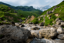
Qusar is located in Eurasian continent, in the north-eastern inclination of the main Caucasus Mountain ridge. It is located between 41°11’ - 41°45’ latitude North and 47°52’ - 48°41’ longitude East. Mountains, among which is also Shahdagh Mount, take the great part of the rayon. Territory of the rayon occupies the north-eastern part of Azerbaijan. Qusar is a unique gate of the republic. Even in the ancient times the territory of the rayon took a good position on a junction of the main trade roads. It is 179 kilometers from Qusar to Baku.
The local relief within Qusar district consists of mountains and valleys. Mineral sources such as limestone, chalcopyrite, limonite, and marble are common in the district. Qusar and Samur are main rivers of the Qusar District.[7]
Qusar rayon is located far from sea routes. The most nearest seas to it are – the Caspian Sea (15 km) and the Black Sea (550 km). Area of the rayon consists of 1542 km2 and occupies 1,7% area of Azerbaijan. For size of its territory Qusar takes the 14th place among the other rayons of Azerbaijan. Length of the rayon from West to East is 84 km, but from North to South it is 35 km.
Extreme points of the rayon are:
Length of the rayons borders is 225 km. Extension of the borders in kilometers:
- Dagestan Republic (with Akhtin, Dokuzpara and Mahammadkend rayons) 95 km.
- Qabala Rayon 25 km.
- Quba Rayon 70 km.
- Khachmaz Rayon 65 km.
Flora and Fauna
Oak, peanut and hornbeam are often found in the forest areas.[7] Natural herbs such as cranberry, sumac, hawthorn, wild grapes and blackberries are also grown in the forests.
Wolf, fox, bear, boar, mountain goat and rabbit are particular for forests of the district. There is wild pigeon, quail, green duck and partridge birds in the fields and lakes.[8]
Population
According to data of 2007, population of the rayon consists of 85 899 people and 98,67% are Lezgins and 0,86% are the Azerbaijanis.[9] According to the data of 2009, Lezgins are 90.5%, Azerbaijanis are 9.1% and other nationalities - 0.4%. As of 2016, population of rayon grew to 96199 people.[10] Lezgins constituted 2% of the total population of Azerbaijan in 2009 who commonly settled in Qusar district.[11][12] National composition was indicated below in accordance with statistics in 2009.[13]
| Nationalities | Percent |
| Azerbaijanis | 9,06 |
| Lezgins | 90,63 |
| Turkish people | 0,12 |
| Russians | 0,10 |
| Khinalug people | 0,02 |
| Qrız | 0,01 |
| Tatars | 0,01 |
| Ukranians | 0,01 |
| Other nationalities | 0,04 |
The urban population in 2017 accounted for 21% and 79% of the district’s population lives in the village.[7]
History
The earliest sediments in the district belong to the Jurassic Period and count 135-145 million years. It is estimated that the life in Gusar district has been existing from the 2nd millennium B.C. Mahmudtapa, the hills of Monsar, the Govdushan hills, the hills of Hafla belonging to the Bronze Age, the hills of Kyzylgul and Agahan, the Halakhur hills belonging to the Middle Ages are ancient dwellings dating back to the 1st millennium B.C.[6]
The district was originated in 1930, and called Gil Rayon with a center in Gil village. In 1934, the center of the rayon was moved to Qusar, and in 1938 it was renamed to Qusar Rayon.
Administrative structure:
- Qullar Village
- Urva Village
Sightseeing
Shaykh Junayd Mausoleum in Yargun (Hazra) village. There are also the remains of the walls of the fortress in the village of Anig belonging to the 13th century, Kohne Khudat and Huray mosques, belonging to the 18th century, Gil, Gyunduzgala and Hasangala mosques, belonging to the 19th century.[14][15] There is a museum named after Russian poet Michael Lermentov.[16]
Religion
- Muslims 98%
Sports and Tourism
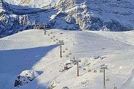
Qusar is home of Shahdag Mountain Resort one of the biggest ski resorts in Caucasus and Azerbaijan's first and largest winter resort. Tourist facilities also include such rescreational areas as "Alpine Gusar", "Star Gusar", "Gayi Bulak", mountain tourism recreation area "Suvar" and Olympic Sports Complex.
Education
There are 48 secondary schools, 86 general-education schools, 4 non-formal and 13 pre-school education facilities.
In addition, 3 large sports facilities are functioning in Gusar district: Olympic Sports Complex, Central Stadium named after Shovkat Ordukhanov, Children and Youth Sports School.[17]
Economy
Agriculture is a basis of the region’s economy. Sown area comprises 34,403 hectares (42,2%) of the 8,1460 hectares of land suitable for agriculture. The area of irrigated lands is 29,398 hectares. Agriculture of this region is based on two main fields – crop production and animal husbandry.[18]
Health-care
There are 3 hospital establishments, 19 health posts, 38 medical centers and 61 medical institutions in Gusar district.[19]
Noted residents
Names of the cities and villages
There is 1 city, 1 settlement respectively, Samur and Qusar and 88 villages in the district.[7]
Qusar executive authority
Executive authority led by Shair Alkhanov since 2007. Under the head of the executive authority, there is acted Council consisted of thirteen members. Villages are controlled by overall 29 municipalities.[20][21][22]
References
- ↑ Äliyev, redaksiya heyätinin sädri, Ilham Heydär oğlu (2007). Azärbaycan : Azärbaycan milli ensiklopediyası. Bakı: "Azärbaycan Milli Ensiklopediyası" Elmi märkäzi. ISBN 9789952441017.
- ↑ "Şəhərlərarası telefon kodları". Aztelekom MMC. Aztelekom İB. Retrieved 19 August 2015. (in Azerbaijani)
- ↑ "Qusar".
- ↑ "Кусарский район".
- ↑ "Gusar". discoverazerbaijan.az.
- 1 2 "QUSAR RAYON İCRA HAKİMİYYƏTİ. Tarixi".
- 1 2 3 4 "About - QUSAR RAYON Icra Hakimiyyəti". www.qusar-ih.gov.az. Retrieved 2018-07-05.
- ↑ "Qusar rayonunun füsunkar təbiəti turistləri ilin bütün fəsillərində məftun edir" (in Azerbaijani). Retrieved 2018-07-05.
- ↑ "Qusar rayonu". The State Statistical Committee of the Republic of Azerbaijan.
- ↑ "QUSAR RAYON İCRA HAKİMİYYƏTİ".
- ↑ Verda, Matteo (2014-12-16). Azerbaijan: An introduction to the Country. Edizioni Epoké. ISBN 9788898014361.
- ↑ Nuriyev, Elkhan (2007). The South Caucasus at the Crossroads: Conflicts, Caspian Oil and Great Power Politics. Lit. ISBN 9783825862169.
- ↑ (www.anarsamadov.net), Anar Samadov. "Qusar rayonu | The State Statistical Committee of the Republic of Azerbaijan". The State Statistical Committee of the Republic of Azerbaijan. Retrieved 2018-07-05.
- ↑ "Гусар – край рекордов и рекордсменов".
- ↑ "QUSAR RAYON İCRA HAKİMİYYƏTİ. Mədəniyyət".
- ↑ "Qusar rayonunun füsunkar təbiəti turistləri ilin bütün fəsillərində məftun edir" (in Azerbaijani). Retrieved 2018-07-07.
- ↑ "QUSAR RAYON İCRA HAKİMİYYƏTİ. Tehsil".
- ↑ "QUSAR RAYON İCRA HAKİMİYYƏTİ. İqtisadiyyat".
- ↑ "QUSAR RAYON İCRA HAKİMİYYƏTİ. Səhiyyə".
- ↑ "İcra hakimiyyətinin başçısı - QUSAR RAYON Icra Hakimiyyəti". www.qusar-ih.gov.az. Retrieved 2018-07-07.
- ↑ "Şura - QUSAR RAYON Icra Hakimiyyəti". www.qusar-ih.gov.az. Retrieved 2018-07-07.
- ↑ "Bələdiyyələr - QUSAR RAYON Icra Hakimiyyəti". www.qusar-ih.gov.az. Retrieved 2018-07-07.