Quilpie, Queensland
| Quilpie Queensland | |||||||||||||||
|---|---|---|---|---|---|---|---|---|---|---|---|---|---|---|---|
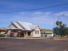
 Brolga St, the main street of Quilpie | |||||||||||||||
 Quilpie | |||||||||||||||
| Coordinates | 26°37′S 144°16′E / 26.617°S 144.267°ECoordinates: 26°37′S 144°16′E / 26.617°S 144.267°E | ||||||||||||||
| Population | 574 (2011 census)[1] | ||||||||||||||
| Established | 1917 | ||||||||||||||
| Postcode(s) | 4480 | ||||||||||||||
| Location |
| ||||||||||||||
| LGA(s) | Shire of Quilpie | ||||||||||||||
| State electorate(s) | Warrego | ||||||||||||||
| Federal Division(s) | Maranoa | ||||||||||||||
| |||||||||||||||
Quilpie (/ˈkwɪlpi/ KWIL-pee) is a town and a locality situated in the Channel Country of South West Queensland, Australia.[2][3] The town is the administrative centre of the Quilpie Shire local government area. In the 2011 census, Quilpie had a population of 574 people.[1]
The economy of the area is based on the grazing and mining industries. The area has one of the largest deposits of boulder opal in the world, and also has extensive deposits of gas and oil.
Geography
Situated on the banks of the Bulloo River and on the Diamantina Developmental Road, it is 208 kilometres (129 mi) west of Charleville, and 980 kilometres (610 mi) west of the state capital, Brisbane. Quilpie is the administrative centre of the Quilpie Shire, which at the 2006 census had a population of 986.[4] Other townships in the shire include Adavale and Eromanga.
In the 2006 census, Quilpie had a population of 560, a decline from the 2001 census population of 645.[4][5] Around 14% of the population of Quilpie identity as Aboriginal or Torres Strait Islander and around 2% were born outside Australia.[4]
History
Quilpie was gazetted as a town in 1917 owing to the railway that was laid down from Brisbane.[6] The town is believed to lie on the border of the Bunthamurra and Mardgany Indigenous Australian tribal areas.[7] The town was originally called mistakenly (by Railways Department) Quillpill, terminus of the Western Line. The town and station name changed to Quilpie 16 June 1917 by Governor in Council.[8][9]
The local government centre was previously Adavale within Adavale Shire, but this was moved to Quilpie with the availability of rail transport and the name change to Quilpie Shire.[10] It takes its name from the Indigenous Australian word for stone curlew, quilpeta.[2][3][11] The first post office was opened in 1921. Two years later the telephone reached Quilpie and in 1927 the first court house in the town was established.[10]
A fire destroyed a block of the main street in 1926.[10] With no town water the residents watched helplessly. A bore was sunk into the Great Artesian Basin in 1933. It provided drinking water for the town and for a period between 1952 and 1963 the hot water was used to generate electricity for the town.[10]
At the 2006 census, Quilpie had a population of 560.[12]
The current Quilpie Public Library building opened in 2005.[13]
Economy
The area is wholly devoted to grazing. Boulder opal, oil and gas mining are major secondary industries for the local economy. The majority of the employees of these industries are local residents, with low rates of both unemployment and itinerant work.
Flora and fauna
The most common species of trees in the district are:[14]
There are a large range of animals (including reptiles and insects) that are can be found in the area including:
- Bearded dragon
- Sand goanna (Varanus gouldii) - bungarra in some aboriginal languages
- Black-headed python
- Inland taipan (Oxyuranus microlepidotus) - also known as western taipan and fierce snake
- Mulga snake (Pseudechis australis) - also known as the king brown
- Brolga (Grus rubicunda)
- Emu (Dromaius novaehollandiae)
- Wedge-tailed eagle (Aquila audax)
- Red kangaroo (Macropus rufus)
- Eastern grey kangaroo (Macropus giganteus)
- Common wallaroo (Macropus robustus)
- Bilby (Macrotis lagotis)
- Water rat (Hydromys chrysogaster)
- Dingo
Facilities and services
Quilpie residents enjoy free access to many amenities including the town library, swimming pool, golf course, museum, sports grounds, an air-conditioned hall and supper room etc. There are well stocked stores and plenty of attractions for visitors with displays of opals and the works of local artists and as well as an information centre. The Brick Hotel[15] has been restored to house displays of opal and art and provide a community learning space.[16]
Quilpie Shire Council operates Quilpie Shire Library, 52 Brolga Street, Quilpie.[17]
Education
Quilpie State School was founded in 1918. It is now known as Quilpie State College. The school began offering secondary education in 1966 and now operates as a P-10 school.[18] The Josephite sisters founded St. Finbarr's primary school in the 1950, although it is now under lay administration. It was the last rural Catholic primary boarding school in Queensland when boarding facilities closed in 2008. Eromanga State School currently operates in the township of Eromanga approximately 90 km west of Quilpie. It has had a chequered history when it was open in the following years - 1897-1908, 1910-1911, 1917–1936, 1967-1981, 1990–present.
Many other public schools have operated in the Quilpie district. The Milo Provisional School was functional between 1888 and 1906. Adavale State School had a long history from 1888-1968. Cheepie State School opened in 1915 and closed in 1974. The Toompine Provisional School was open between 1900 and 1902, for a time operating as a half-time school with Duck Creek State School which was open between 1901 and 1905. The Goombie State School operated between 1875 and 1977.
Climate
Quilpie has a semi-arid climate with hot summers and mild, spring-like winters.
| Climate data for Quilpie | |||||||||||||
|---|---|---|---|---|---|---|---|---|---|---|---|---|---|
| Month | Jan | Feb | Mar | Apr | May | Jun | Jul | Aug | Sep | Oct | Nov | Dec | Year |
| Record high °C (°F) | 47.1 (116.8) |
45.5 (113.9) |
42.9 (109.2) |
38.4 (101.1) |
34.5 (94.1) |
32.1 (89.8) |
29.4 (84.9) |
37.0 (98.6) |
40.1 (104.2) |
43.8 (110.8) |
44.9 (112.8) |
46.1 (115) |
47.1 (116.8) |
| Average high °C (°F) | 37.0 (98.6) |
35.6 (96.1) |
33.4 (92.1) |
29.2 (84.6) |
24.0 (75.2) |
20.4 (68.7) |
20.1 (68.2) |
22.7 (72.9) |
27.1 (80.8) |
31.1 (88) |
34.0 (93.2) |
36.1 (97) |
29.2 (84.6) |
| Average low °C (°F) | 23.8 (74.8) |
23.3 (73.9) |
20.5 (68.9) |
15.7 (60.3) |
10.9 (51.6) |
7.4 (45.3) |
6.1 (43) |
7.7 (45.9) |
11.7 (53.1) |
16.1 (61) |
19.6 (67.3) |
22.2 (72) |
15.4 (59.7) |
| Record low °C (°F) | 13.7 (56.7) |
13.3 (55.9) |
9.6 (49.3) |
3.5 (38.3) |
1.0 (33.8) |
−1.2 (29.8) |
−2.3 (27.9) |
−1.0 (30.2) |
2.1 (35.8) |
5.4 (41.7) |
8.6 (47.5) |
12.3 (54.1) |
−2.3 (27.9) |
| Average precipitation mm (inches) | 52.6 (2.071) |
50.7 (1.996) |
43.3 (1.705) |
24.8 (0.976) |
26.9 (1.059) |
20.0 (0.787) |
16.7 (0.657) |
12.5 (0.492) |
14.0 (0.551) |
21.6 (0.85) |
30.9 (1.217) |
34.5 (1.358) |
348.7 (13.728) |
| Average precipitation days | 4.8 | 4.5 | 3.9 | 2.5 | 2.8 | 2.8 | 2.7 | 2.2 | 2.5 | 3.6 | 4.1 | 4.5 | 40.9 |
| Source: [19] | |||||||||||||
Events
Notable people from Quilpie
- Vaughan Johnson, Queensland state politician
- Ewen Jones, Australian federal politician
- Professor Don Markwell, social scientist and educational leader
- Sandy McPhie, former Queensland state politician
- Justine Saunders, late Australian actor
Gallery


See also
References
- 1 2 Australian Bureau of Statistics (31 October 2012). "Quilpie (SSC)". 2011 Census QuickStats. Retrieved 23 July 2014.

- 1 2 "Quilpie (town) (entry 27822)". Queensland Place Names. Queensland Government. Retrieved 23 July 2014.
- 1 2 "Quilpie (locality) (entry 42939)". Queensland Place Names. Queensland Government. Retrieved 23 July 2014.
- 1 2 3 Australian Bureau of Statistics (25 October 2007). "Quilpie (S) (Local Government Area)". 2006 Census QuickStats. Retrieved 15 March 2012.
- ↑ Australian Bureau of Statistics (9 March 2006). "Tambo (L) (Urban Centre/Locality)". 2001 Census QuickStats. Retrieved 15 March 2012.
- ↑ Walkabout - Quilpie Archived 8 June 2007 at the Wayback Machine.
- ↑ Jenkins, Lesley (January 2001). Lure of the Land: A Brief History of the Quilpie Shire (PDF). Retrieved 23 July 2014.
- ↑ "Queensland Place Names". Department of Natural Resources and Mines. Retrieved 21 April 2017.
- ↑ "WESTERN RAILWAY". The Daily Mail (4422). Queensland, Australia. 1 May 1917. p. 4. Retrieved 21 April 2017 – via National Library of Australia.
- 1 2 3 4 Environmental Protection Agency (Queensland) (2002). Heritage Trails of the Queensland Outback. State of Queensland. pp. 104–105. ISBN 0-7345-1040-3.
- ↑ http://www.exploreaustralia.net.au/Queensland/Outback/Quilpie
- ↑ Australian Bureau of Statistics (25 October 2007). "Quilpie (L) (Urban Centre/Locality)". 2006 Census QuickStats. Retrieved 2008-07-21.
- ↑ "Public Libraries Statistical Bulletin 2016-17" (PDF). Public Libraries Connect. November 2017. Retrieved 29 January 2018.
- ↑ Quilpie Shire Council, "Tracks and Facts of Quilpie Shire" 2011 p. 13
- ↑ The pub with no beer
- ↑ Community Learning Space Archived 29 September 2007 at the Wayback Machine.
- ↑ "Quilpie Shire Library". Public Libraries Connect. State Library of Queensland. Retrieved 23 January 2018.
- ↑ "School History". Quilpie State School. 20 June 2011. Retrieved 15 March 2012.
- ↑ "Climate statistics for Quilpie". Bureau of Meteorology. Retrieved 1 April 2014.
- ↑ "Archived copy". Archived from the original on 8 August 2014. Retrieved 1 August 2014.
- ↑ "Archived copy". Archived from the original on 27 February 2015. Retrieved 4 June 2015.
- ↑ http://quilpie.qld.gov.au/events/
Further reading
- Jenkins, Lesley (January 2001). Lure of the Land: A Brief History of the Quilpie Shire (PDF).
External links
![]()
- University of Queensland: Queensland Places: Quilpie and Quilpie Shire
- Official website of Shire of Quilpie
- Living in Quilpie by Ben Hall, a 3 min 20 sec video, published by State Library of Queensland as part of Storylines:Q150 digital stories