Quehuisha (Peru)
| Quehuisha | |
|---|---|
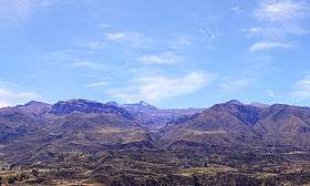 The Callumayo valley leading to Quehuisha in the background (center) | |
| Highest point | |
| Elevation | 5,514 m (18,091 ft) [1] |
| Coordinates | 15°31′14″S 71°45′33″W / 15.52056°S 71.75917°WCoordinates: 15°31′14″S 71°45′33″W / 15.52056°S 71.75917°W |
| Geography | |
 Quehuisha Peru | |
| Location | Peru, Arequipa Region |
| Parent range | Andes, Chila |
Quehuisha (possibly from Quechua for Amaranthus caudatus or for liver)[2], Quehuicha, Queshihua, or Quihuisha is a mountain in the Chila mountain range in the Andes of Peru, about 5,514 metres (18,091 ft) high (according to another source 5,170 metres (16,962 ft)).[3] It is located in the Arequipa Region, Caylloma Province, Lari District, west of the mountain Mismi.[4]
The river Callumayo originates south of Quehuisha, between the small lakes Ticllacocha (possibly from Quechua for "two-colored lake") and Jatuncocha (possibly from Quechua for "big lake") near the little village Quihnisha. It flows to the south and ends in the Colca River .
References
- ↑ archive.is Amazon River : widest and longest
- ↑ Teofilo Laime Ajacopa, Diccionario Bilingüe Iskay simipi yuyayk'ancha, La Paz, 2007 (Quechua-Spanish dictionary)
- ↑ www.uni.edu.pe
- ↑ escale.minedu.gob.pe - UGEL map of the Caylloma Province (Arequipa Region)
This article is issued from
Wikipedia.
The text is licensed under Creative Commons - Attribution - Sharealike.
Additional terms may apply for the media files.