Qaasuitsup
| Qaasuitsup Kommunia | |||||
| Municipality of Greenland | |||||
| |||||
 | |||||
 | |||||
| Capital | Ilulissat 69°13′N 51°06′W / 69.217°N 51.100°WCoordinates: 69°13′N 51°06′W / 69.217°N 51.100°W | ||||
| Government | Constitutional monarchy | ||||
| Mayor | Ole Dorph | ||||
| History | |||||
| • | Established | 1 January 2009 | |||
| • | Disestablished | 31 December 2017 | |||
| Area | |||||
| • | 2017 | 660,000 km2 (254,827 sq mi) | |||
| Population | |||||
| • | 2017 | 17,147 | |||
| Density | 0 /km2 (0.1 /sq mi) | ||||
| Population data:[1]; ISO code: GL-QA; Calling code: +299 | |||||
Qaasuitsup (Greenlandic: [qaːsui̯tsup̚] Place of Polar Darkness) was a municipality in Greenland, operational from 1 January 2009[2] to 31 December 2017.[3] As of January 2013 its population was 17,498.[1] The administrative centre of the municipality was in Ilulissat (formerly called Jakobshavn). The municipality consisted of the former municipalities of western and northern Greenland, each named after the biggest settlement:
- Aasiaat Municipality
- Kangaatsiaq Municipality
- Ilulissat Municipality
- Qaanaaq Municipality
- Qasigiannguit Municipality
- Qeqertarsuaq Municipality
- Uummannaq Municipality
- Upernavik Municipality
Effective January 1, 2018, Qaasuitsup Kommunia was partitioned into two new municipalities: Avannaata Kommunia, comprising Ilulissat, Uummannaq, Upernavik, Qaanaaq and surrounding settlements; and Kommune Qeqertalik, comprising Aasiaat, Qasigiannguit, Qeqertarsuaq, Kangaatsiaq and surrounding settlements.[3]
Geography
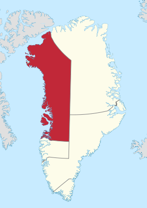
The municipality was located in northwestern Greenland. With an area of 660,000 km2 (254,827.4 sq mi),[4] it was the largest municipality in the world by area,[5] larger than France at 643,427 km2 (248,428.6 sq mi).[6]
In the south, it was flanked by the Qeqqata municipality. In the southeast, it was bordered by the Sermersooq municipality, however this border ran north-south (45° West meridian) through the center of the Greenland ice sheet (Greenlandic: Sermersuaq), and as such was free of traffic. In the east and northeast it was bordered by the Northeast Greenland National Park.
At the southern end of the municipal coastline were the waters of Disko Bay, an inlet of the larger Baffin Bay, which to the north edges into the island of Greenland in the form of Melville Bay. The coastline of northeastern Baffin Bay is dotted with islands of the Upernavik Archipelago, which was entirely contained within the municipality. In the far northwest near Qaanaaq and Siorapaluk, the municipal shores extended into Nares Strait, which separates Greenland from Ellesmere Island.
Denmark claimed Hans Island as part of Qaasuitsup (now Avannaata), while Canada considers it to be part of the Nunavut region of Qikiqtaaluk.
Towns and settlements
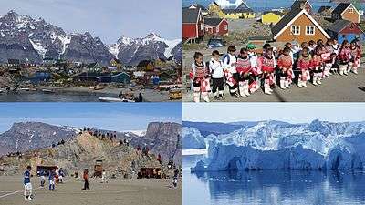
- Aasiaat area
- Aasiaat (Egedesminde)
- Akunnaaq
- Kitsissuarsuit (Hunde Ejlande, Dog's Island)
- Ilulissat area
- Kangaatsiaq area
- Kangaatsiaq (Prøven)
- Attu
- Iginniarfik
- Ikerasaarsuk
- Niaqornaarsuk
- Qaanaaq area
- Qaanaaq (Thule)
- Qeqertat
- Savissivik
- Siorapaluk
- Qasigiannguit area
- Qasigiannguit (Christianshåb)
- Ikamiut
- Qeqertarsuaq area
- Qeqertarsuaq (Godhavn)
- Kangerluk
- Uummannaq area
- Upernavik area
- Upernavik (Women's Island)
- Aappilattoq
- Innaarsuit
- Kangersuatsiaq
- Kullorsuaq
- Naajaat
- Nutaarmiut
- Nuussuaq (Kraulshavn)
- Tasiusaq
- Tussaaq
- Upernavik Kujalleq (Søndre Upernavik)
Language
Kalaallisut, the West Greenlandic dialect, is spoken in the towns and settlements of the western and northwestern coasts. Inuktun is also spoken in and around Qaanaaq.
See also
References and notes
| Wikimedia Commons has media related to Qaasuitsup. |
- 1 2 http://bank.stat.gl/pxweb/en/Greenland/Greenland__BE__BE01__BE0120/BEXST2.PX/?rxid=cc3fa9f7-1302-4aa1-bfb1-8a95b7e92399
- ↑ Qaasuitsup Municipality (in Greenlandic)
- 1 2 "Nittartakkat nutaat: avannaata.gl kiisalu qeqertalik.gl". Retrieved 2018-01-07.
- ↑ "Fakta om kommunen" (in Danish). Qaasuitsup Municipality, Official Website. Archived from the original on 30 October 2010. Retrieved 8 July 2010.
- ↑ not considering the Chilean Antarctic commune, which is not internationally recognized
- ↑ France Archived 2010-02-14 at WebCite at the CIA World Factbook
External links
Administrative divisions of Greenland (since 2018) | ||
|---|---|---|
| Municipalities | ||
| Unincorporated Areas |
| |