Pyhtää
| Pyhtää Pyhtää – Pyttis | ||
|---|---|---|
| Municipality | ||
|
Pyhtään kunta Pyttis kommun | ||
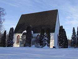 The medieval St. Henry's church | ||
| ||
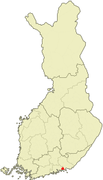 Location of Pyhtää in Finland | ||
| Coordinates: 60°30′N 026°33′E / 60.500°N 26.550°ECoordinates: 60°30′N 026°33′E / 60.500°N 26.550°E | ||
| Country |
| |
| Region | Kymenlaakso | |
| Sub-region | Kotka-Hamina sub-region | |
| Founded | ca. 1380 | |
| Government | ||
| • Municipality manager | Olli Ikonen | |
| Area (2018-01-01)[1] | ||
| • Total | 780.96 km2 (301.53 sq mi) | |
| • Land | 324.72 km2 (125.38 sq mi) | |
| • Water | 456.24 km2 (176.16 sq mi) | |
| Area rank | 228th largest in Finland | |
| Population (2018-08-31)[2] | ||
| • Total | 5,243 | |
| • Rank | 170th largest in Finland | |
| • Density | 16.15/km2 (41.8/sq mi) | |
| Population by native language[3] | ||
| • Finnish | 88.3% (official) | |
| • Swedish | 9.6% (official) | |
| • Others | 2.1% | |
| Population by age[4] | ||
| • 0 to 14 | 17.3% | |
| • 15 to 64 | 63.5% | |
| • 65 or older | 19.1% | |
| Time zone | UTC+2 (EET) | |
| • Summer (DST) | UTC+3 (EEST) | |
| Municipal tax rate[5] | 19.75% | |
| Climate | Dfb | |
| Website | www.pyhtaa.fi | |

Pyhtää (Swedish: Pyttis) is a municipality of Finland.
Overview
It is located in the Kymenlaakso region. The municipality has a population of 5,243 (31 August 2018)[2] and covers an area of 780.96 square kilometres (301.53 sq mi) of which 456.24 km2 (176.16 sq mi) is water.[1] The population density is 16.15 inhabitants per square kilometre (41.8/sq mi).
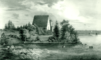
The medieval church (as opposed to the municipality) is situated in the village of Itäkirkonkylä ("East Church Village"). During the Reformation, the rather beautiful and moving pictures on the walls were whitewashed over. Some years ago, they were rediscovered and the whitewash removed. The village lies just to the East of the westernmost tributary of the Kymi River and was at one time on the border between Russia and Sweden established by the Treaty of Åbo in 1743. Indeed, on the Western side of the river is a municipality called Ruotsinpyhtää ("Swedish Pyhtää") known as Strömfors in Swedish.
The municipality is bilingual with 88.3% speaking Finnish, 9.6% Swedish and 2.1% other languages as their first language.[3]
Villages
- Heinlahti (Swedish: Heinlax)
- Hinkaböle
- Hirvikoski (earlier Österhirvikoski)
- Itäkirkonkylä (Swedish: Österkyrkoby)
- Itämyllynkylä (Swedish: Österkvarnby)
- Kaunissaari (Swedish: Fagerö)
- Kiviniemi (Swedish: Stensnäs, earlier Lillkuppis)
- Loosari (Swedish: Klåsarö)
- Länsikirkonkylä (Swedish: Västerkyrkoby)
- Länsikylä (Swedish: Västerby, earlier Västerkuppis)
- Länsimyllynkylä (Swedish: Västerkvarnby)
- Malmi, Pyhtää (Swedish: Malm)
- Munapirtti (Swedish: Mogenpört)
- Pirtnuora (Swedish: Pörtnor)
- Siltakylä (Swedish: Broby, earlier Storkuppis)
- Suur-Ahvenkoski (Swedish: Storabborrfors)
- Tuuski (Swedish: Tuskas; de jure a part of Munapirtti)
- Purola
Twinnings

References
- 1 2 "Area of Finnish Municipalities 1.1.2018" (PDF). National Land Survey of Finland. Retrieved 30 January 2018.
- 1 2 "Ennakkoväkiluku kuukausittain sukupuolen mukaan alueittain, elokuu 2018" (in Finnish). Statistics Finland. Retrieved 21 October 2018.
- 1 2 "Population according to language and the number of foreigners and land area km2 by area as of 31 December 2008". Statistics Finland's PX-Web databases. Statistics Finland. Retrieved 29 March 2009.
- ↑ "Population according to age and gender by area as of 31 December 2008". Statistics Finland's PX-Web databases. Statistics Finland. Retrieved 28 April 2009.
- ↑ "List of municipal and parish tax rates in 2011". Tax Administration of Finland. 29 November 2010. Retrieved 13 March 2011.
- ↑ "Sõprusvallad" (in Estonian). Haljala vald. Retrieved 4 May 2012.
External links

- Municipality of Pyhtää – Official website (in Finnish) (in Swedish)
- Map of Pyhtää
| Municipalities |  | |
|---|---|---|
| Former municipalities |
| |