Puyallup Glacier
| Puyallup Glacier | |
|---|---|
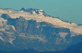 Puyallup Glacier and Puyallup Cleaver | |
| Type | Mountain glacier |
| Location | Mount Rainier, Pierce County, Washington, USA |
| Coordinates | 46°50′59″N 121°49′27″W / 46.84972°N 121.82417°W |
| Area | 2.0 square miles (5.2 km2), 1983[1] |
The Puyallup Glacier is a glacier on the west flank of Mount Rainier in Washington. It covers 2.0 square miles (5.2 km2) and contains 10.2 billion ft3 (289 million m3) of ice.[1] Sharing the same source of ice as the northern South Mowich Glacier, the Puyallup Glacier begins as a branch off the ice stream that flow out of the Sunset Amphitheater.[2] From the split at around 8,500 feet (2,600 m), the glacier expands into a broad sheet of ice ranging from 8,400 feet (2,600 m) to 7,400 feet (2,300 m) in elevation. Leaving the large expanse of ice, the glacier flows down a small valley, it narrows significantly as it turns northwestward. From there on, the glacier is dirty and ends on steep, uneven terrain at about 6,000 ft (1,800 m).[2] The glacier gives rise to the Puyallup River.[1]
See also
References
- 1 2 3 "DESCRIPTION: Mount Rainier Glaciers and Glaciations - Mount Rainier Glacier Hazards and Glacial Outburst Floods". USGS. Retrieved 2007-11-19.
- 1 2 "Puyallup Glacier, USGS Mount Rainier West (WA) Topo Map". USGS Quad maps. TopoQuest.com. Retrieved 2008-05-17.