Puy de Dôme
| Puy de Dôme | |
|---|---|
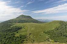
 General view | |
| Highest point | |
| Elevation | 1,465 m (4,806 ft) [1] |
| Coordinates | 45°46′19″N 02°57′45″E / 45.77194°N 2.96250°ECoordinates: 45°46′19″N 02°57′45″E / 45.77194°N 2.96250°E |
| Geography | |
 Puy de Dôme France | |
| Location | Puy-de-Dôme, Auvergne, France |
| Parent range | Chaîne des Puys region of Massif Central |
| Geology | |
| Mountain type | Lava dome |
| Last eruption | ca 10,700 years ago[2] |
| Climbing | |
| First ascent | Unknown |
| Easiest route | road |
Puy de Dôme (French pronunciation: [pɥi də dom]; (Auvergnat Puèi Domat, Puèi de Doma) is a large lava dome and one of the youngest volcanoes in the Chaîne des Puys region of Massif Central in central France. This chain of volcanoes including numerous cinder cones, lava domes, and maars is far from the edge of any tectonic plate. Puy de Dôme was created by a Peléan eruption, some 10,700 years ago. Puy de Dôme is approximately 10 kilometres (6 mi) from Clermont-Ferrand. The Puy-de-Dôme département (with hyphens) is named after the volcano.
History
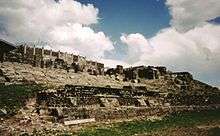
In pre-Christian Europe, Puy de Dôme served as an assembly place for spiritual ceremonies.[3] Temples were built at the summit, including a Gallo-Roman temple dedicated to the God Mercury, the ruins of which were discovered in 1873.
In 1648, Florin Périer, at the urging of Blaise Pascal, proved Evangelista Torricelli's theory that barometric observations were caused by the weight of air by measuring the height of a column of mercury at three elevations on Puy de Dôme.
In 1875, a physics laboratory was built at the summit. Since 1956, a TDF (Télédiffusion de France) antenna is also located there. On the top of the mountain, there is a transmitter for FM and TV.
Tourism
The Puy de Dôme is one of the most visited sites in the Auvergne region, attracting nearly 500,000 visitors a year. The summit offers expansive views of the Chaîne des Puys and Clermont-Ferrand. It is a well-known centre for paragliding.
The summit can be reached by two pedestrian paths: a southern one ("Le sentier des muletiers", formerly a Roman road) and a northern one ("Le sentier des chèvres") which runs past the Nid de la Poule crater. The GR 4 long-distance trail includes both paths to cross the mountain.
Since May 2012, visitors can also go up the mountain by train with the Panoramique des Dômes, a rack railway.
A road exists along the train tracks but it is closed to the general traffic, except for the military, service vehicles or emergencies.
At the top of the mountain, restaurants and shops are available as well as a visitor centre giving information on the history and geology of the area.
Sport
Cycling
In more recent times, Puy de Dôme has served as an occasional stage finish in the Tour de France. It was here that in 1964 Raymond Poulidor battled with Jacques Anquetil in one of the race's most famous moments, racing side by side up almost the entire climb; and that in 1975 Eddy Merckx was punched in the kidney by a spectator. According to Jean-François Pescheux, since the construction of a rack railway, and because of the very narrow road, the Tour will never come back to the Puy de Dôme, its last ascension in the race being in 1988.[4]

The road is only open for cyclists during very limited periods (when other vehicles are prohibited). In 2006 this was 7–9am on Wednesdays and Sundays between 1 May and 30 September.[5] In 2017, it will be the first checkpoint in the Transcontinental Race, which is a non-stop, unsupported bicycle race across Europe.[6]
Motorsports
The Circuit de Charade was a motorsport street circuit built in 1957 using pre-existing roads around the base of the Puy de Dôme.[7][8] The venue hosted the French Grand Prix as well as the French motorcycle Grand Prix several times in the 1960s and early 1970s.[7][8] In 1986, the track was shortened due to safety issues and was converted into a dedicated motorsport race track hosting track days, driving schools as well as historic motorsport events.[7][8][9]
Climate
Puy de Dôme has a climate significantly cooled by its high elevation. While lower areas of the mountain are firmly oceanic (Köppen Cfb), the summit weather station is bordering between oceanic, subalpine (Dfc) and humid continental (Dfb).
| Climate data for Puy de Dôme (1981–2010 normals; extremes 1973–2017) | |||||||||||||
|---|---|---|---|---|---|---|---|---|---|---|---|---|---|
| Month | Jan | Feb | Mar | Apr | May | Jun | Jul | Aug | Sep | Oct | Nov | Dec | Year |
| Record high °C (°F) | 14.0 (57.2) |
12.8 (55) |
18.0 (64.4) |
20.8 (69.4) |
22.7 (72.9) |
28.4 (83.1) |
26.8 (80.2) |
28.3 (82.9) |
24.4 (75.9) |
21.3 (70.3) |
17.1 (62.8) |
17.0 (62.6) |
28.3 (82.9) |
| Average high °C (°F) | −0.5 (31.1) |
0.1 (32.2) |
3.6 (38.5) |
7.8 (46) |
9.8 (49.6) |
13.6 (56.5) |
16.7 (62.1) |
16.8 (62.2) |
12.8 (55) |
9.3 (48.7) |
5.1 (41.2) |
0.5 (32.9) |
8.2 (46.8) |
| Daily mean °C (°F) | −2.9 (26.8) |
−2.6 (27.3) |
0.9 (33.6) |
4.5 (40.1) |
6.9 (44.4) |
10.3 (50.5) |
13.2 (55.8) |
13.5 (56.3) |
10.1 (50.2) |
6.3 (43.3) |
2.7 (36.9) |
−2.2 (28) |
4.7 (40.5) |
| Average low °C (°F) | −5.4 (22.3) |
−5.2 (22.6) |
−1.8 (28.8) |
1.2 (34.2) |
3.9 (39) |
7.0 (44.6) |
9.7 (49.5) |
10.2 (50.4) |
7.5 (45.5) |
3.3 (37.9) |
0.3 (32.5) |
−4.8 (23.4) |
2.3 (36.1) |
| Record low °C (°F) | −13.4 (7.9) |
−19.0 (−2.2) |
−14.2 (6.4) |
−10.0 (14) |
−9.0 (15.8) |
−3.0 (26.6) |
1.0 (33.8) |
2.0 (35.6) |
−2.0 (28.4) |
−7.0 (19.4) |
−12.0 (10.4) |
−16.8 (1.8) |
−19.0 (−2.2) |
| Average precipitation mm (inches) | 51.5 (2.028) |
41.3 (1.626) |
29.4 (1.157) |
30.9 (1.217) |
65.0 (2.559) |
75.6 (2.976) |
67.9 (2.673) |
53.8 (2.118) |
62.9 (2.476) |
40.9 (1.61) |
43.2 (1.701) |
53.5 (2.106) |
610.0 (24.016) |
| Average precipitation days | 11.5 | 8.5 | 9.2 | 6.0 | 10.3 | 9.6 | 10.3 | 9.4 | 9.0 | 10.3 | 10.3 | 16.0 | 120.4 |
| Source #1: Météo Climat [10] | |||||||||||||
| Source #2: Météo Climat [11] | |||||||||||||
References
- ↑ Nicola Williams, France, p592 - "The ice-flecked summit of Puy de Dôme (1465m)...."
- ↑ D. Miallier, Pierre Boivin, C. Deniel, A. Gourgaud, P. Lanos, M. Sforna, Thierry Pilleyre "The ultimate summit eruption of Puy de Dôme volcano (Chaine des Puys, French Massif Central) about 10,700 years ago", Comptes Rendus Géosciences 342 (2010) 847-854
- ↑ Hubert, Henri (2013-11-12). The Greatness and Decline of the Celts. Routledge. ISBN 9781136202926.
- ↑ "Le Puy-de-Dôme dans le Tour de France" (in French). ledicodutour. Retrieved 19 July 2012.
- ↑ "Puy de Dôme: Clermont Ferrand". www.climbbybike.com. Retrieved 19 July 2012.
- ↑ Beltchenko, Neil. "Transcontinental Race releases 2016 controls". Bikepackers Magazine. Retrieved 26 December 2015.
- 1 2 3 "Charade". racingcircuits.info. Retrieved 4 April 2017.
- 1 2 3 "The Volcanic Rush of Clermont Ferrand". speedhunters.com. Retrieved 4 April 2017.
- ↑ "A Brief History of Charade". theracingline.net. Retrieved 4 April 2017.
- ↑ "French climate normals 1981-2010". Météo Climat. Retrieved 19 September 2018.
- ↑ "Weather extremes for Puy de Dôme". Météo Climat. Retrieved 19 September 2018.
- Scarth, Alwyn; Tanguy, Jean-Claude (2001). Volcanoes of Europe. Oxford University Press. ISBN 0-19-521754-3.
- Global Volcanism Program: Chaîne des Puys
External links
| Wikimedia Commons has media related to Puy de Dôme. |