Puponga
| Puponga | |
|---|---|
 Port Puponga | |
 Puponga | |
| Coordinates: 40°31′30″S 172°40′0″E / 40.52500°S 172.66667°ECoordinates: 40°31′30″S 172°40′0″E / 40.52500°S 172.66667°E | |
| Time zone | UTC+12 (NZST) |
| • Summer (DST) | UTC+13 (NZDT) |
| Area code | 03 |
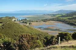
The tiny settlement of Puponga in New Zealand is the northernmost settlement in the South Island.[1] It is in the Tasman District, 18 kilometres (11 mi) north of Collingwood, at the foot of Farewell Spit. The spit's airstrip, Triangle Flat Airstrip is just northeast of Puponga.
Just to the northeast of the village, a car park at a cafe is the starting point for tours of Farewell Spit. Popular walks in the area include short walks to Cape Farewell, the northernmost point of the South Island, and to Wharariki Beach.[2]
References
- ↑ "Puponga, Tasman - NZ Topo Map". NZ Topo Map. Land Information New Zealand. Retrieved 2017-10-12.
- ↑ "Farewell Spit and Puponga Farm Park tracks". Department of Conservation NZ. Retrieved 2017-10-12.
This article is issued from
Wikipedia.
The text is licensed under Creative Commons - Attribution - Sharealike.
Additional terms may apply for the media files.