Puig Neulós
| Puig Neulós | |
|---|---|
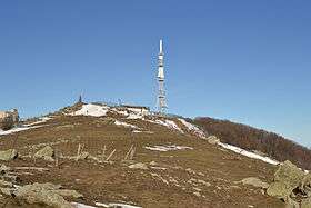 Puig Neulós summit | |
| Highest point | |
| Elevation | 1,256 m (4,121 ft) |
| Coordinates | 42°28′55″N 2°56′49″E / 42.48194°N 2.94694°ECoordinates: 42°28′55″N 2°56′49″E / 42.48194°N 2.94694°E |
| Geography | |
 Puig Neulós Catalonia, Spain | |
| Location |
La Jonquera (Alt Empordà) Sureda (Rosselló) |
| Parent range | Albera Range |
| Climbing | |
| First ascent | Unknown |
| Easiest route | From La Roca d'Albera |
Puig Neulós (French: Pic du Néoulous) is the highest mountain of Albera Range, an eastern prolongation of the Pyrenees in Catalonia, between France and Spain. It has an elevation of 1,256 metres above sea level.[1]
There are some antennas on the summit and there is a paved road on the French side restricted to military use. The summit, as well as most of the southern side of the range is part of the Paratge Natural d'Interès Nacional de l'Albera natural reserve.[2]
A man-made rock formation known as La Reyne de las Founs surrounds a water source coming out of the mountain. Built by 19th century shepherd Emmanuel Coste, known as Manel, it is inscribed with the quotation "les douaniers ici trouvent souvent ce qu'ils cherchent". Later, smugglers used pebble formations to codify messages about customs officials in the viccinity.[3]
See also
- Paratge Natural d'Interès Nacional de l'Albera
- Mountains of Catalonia
References
- ↑ "Mapa Topogràfic de Catalunya". Institut Cartogràfic de Catalunya. Retrieved May 22, 2010. .
- ↑ Paratge Natural d'Interès Nacional de l'Albera Archived 2009-05-24 at the Wayback Machine.
- ↑ "Smugglers at Col d'Ouillat and Pic Neoulous. | P-O Life". anglophone-direct. 2016-04-15. Retrieved 2018-10-14.