Ptghni
| Ptghni Պտղնի | |
|---|---|
 Ptghni | |
 Ptghni Պտղնի | |
| Coordinates: 40°15′24″N 44°35′06″E / 40.25667°N 44.58500°ECoordinates: 40°15′24″N 44°35′06″E / 40.25667°N 44.58500°E | |
| Country | Armenia |
| Marz (Province) | Kotayk |
| Founded | 1831 |
| Government | |
| • Mayor | Arakel Virabyan |
| Area | |
| • Total | 6.22 km2 (2.40 sq mi) |
| Elevation | 1,350 m (4,430 ft) |
| Population (2008) | |
| • Total | 1,337 |
| • Density | 210/km2 (560/sq mi) |
| Time zone | |
| • Summer (DST) | UTC+5 |
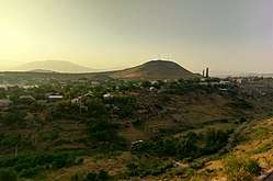
Ptghni (Armenian: Պտղնի), is a village located in the Kotayk Province of Armenia along the left bank of the Hrazdan River. It was founded in 1831 in the vicinity of an abandoned dwelling. The village has a school, kindergarten, house of culture, and a library. The local economy is dependent on agriculture and local inhabitants primarily grow grapes, melons, gourds, and breed cattle. Within the village are the remains of fortress walls and Ptghavank of the 6th to 7th-century.[1][2]
Gallery
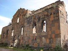 Ptghnavank, 6th-7th c.
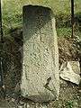 Khachkar monument beside the road leading to the village.
See also
References
- ↑ "Ptghni (Kotayk)". CAA: Union of Communities of Armenia. Retrieved June 2, 2015.
- ↑ Kiesling, Brady; Kojian, Raffi (2005). Rediscovering Armenia: Guide (2nd ed.). Yerevan: Matit Graphic Design Studio. pp. 92–93. ISBN 99941-0-121-8.
External links
- Communities Association of Armenia: Ptghni
- Ptghnavank MonasteryPtghnavank2Ptghnavank3Ptghnavank4Ptghnavank5
Capital: Hrazdan | ||
| Urban communities | 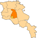 | |
| Rural communities |
| |
| Non-community settlements | ||
This article is issued from
Wikipedia.
The text is licensed under Creative Commons - Attribution - Sharealike.
Additional terms may apply for the media files.