Boulemane Province
Boulemane is a province of Morocco, formerly in the Fès-Boulemane Region. The Fès-Boulemane region became part of Fès-Meknès September 2015 by merging Fès-Boulemane with the prefecture of Meknès and the provinces of El Hajeb and Ifrane (in Meknès-Tafilalet region) and the provinces of Taounate and Taza (in Taza-Al Hoceima-Taounate region).
The province had a population of 185,110 people in 2004.

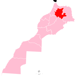
Location of the province Boulemane within the region Fès-Boulemane, Morocco, prior to the merger in 2015. At this time Morocco had 16 regions, subdivided into 62 provinces and 13 prefectures.
Location of the province Fes Meknes, within which the Boulemane Province has been located since 2015. In total, Morocco now has 12 regions.
Subdivisions
The province is divided administratively into the following:[1]
| Name | Geographic code | Type | Households | Population (2004) | Foreign population | Moroccan population | Notes |
|---|---|---|---|---|---|---|---|
| Boulemane | 131.01.01. | Municipality | 1541 | 6910 | 1 | 6909 | |
| Imouzzer Marmoucha | 131.01.02. | Municipality | 908 | 4001 | 1 | 4000 | |
| Missour | 131.01.03. | Municipality | 4286 | 20978 | 28 | 20950 | |
| Outat El Haj | 131.01.05. | Municipality | 2625 | 13945 | 5 | 13940 | |
| Ait Bazza | 131.03.01. | Rural commune | 612 | 3480 | 0 | 3480 | |
| Ait El Mane | 131.03.03. | Rural commune | 440 | 2243 | 0 | 2243 | |
| Almis Marmoucha | 131.03.05. | Rural commune | 445 | 2698 | 0 | 2698 | |
| El Mers | 131.03.07. | Rural commune | 1178 | 5891 | 1 | 5890 | |
| Enjil | 131.03.09. | Rural commune | 1534 | 8164 | 0 | 8164 | |
| Guigou | 131.03.11. | Rural commune | 3694 | 19035 | 1 | 19034 | 7976 residents live in the center, called Guigou; 11059 residents live in rural areas. |
| Serghina | 131.03.13. | Rural commune | 733 | 3726 | 0 | 3726 | |
| Skoura M'Daz | 131.03.15. | Rural commune | 1934 | 8713 | 1 | 8712 | |
| Talzemt | 131.03.17. | Rural commune | 650 | 3710 | 0 | 3710 | |
| Ksabi Moulouya | 131.05.01. | Rural commune | 1759 | 10067 | 1 | 10066 | |
| Ouizeght | 131.05.03. | Rural commune | 963 | 5509 | 0 | 5509 | |
| Sidi Boutayeb | 131.05.05. | Rural commune | 1705 | 9522 | 20 | 9502 | |
| El Orjane | 131.07.01. | Rural commune | 1179 | 7609 | 2 | 7607 | |
| Ermila | 131.07.03. | Rural commune | 1079 | 6774 | 0 | 6774 | |
| Fritissa | 131.07.05. | Rural commune | 3314 | 26022 | 5 | 26017 | |
| Oulad Ali Youssef | 131.07.07. | Rural commune | 1074 | 6669 | 0 | 6669 | |
| Tissaf | 131.07.09. | Rural commune | 1455 | 9444 | 2 | 9442 | |
References
- ↑ "Recensement général de la population et de l'habitat de 2004" (PDF). Haut-commissariat au Plan, Lavieeco.com. Archived from the original (PDF) on 23 April 2012. Retrieved 27 April 2012.
This article is issued from
Wikipedia.
The text is licensed under Creative Commons - Attribution - Sharealike.
Additional terms may apply for the media files.