Promontorium Taenarium
Coordinates: 18°39′0″S 7°28′24″W / 18.65000°S 7.47333°W
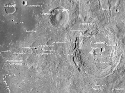
Promontorium Taenarium is a raised mountainous cape located in the eastern end of Mare Nubium. It lies just close to Rupes Recta,[1] the Straight Wall.Its length is about 70 km. Its coordinates are 18°39′0″S 7°28′24″W / 18.65000°S 7.47333°W. Nearby craters are Lassell to the north, Alpetragius to the northeast, Arzachel, the closest to the east, Thebit to the southeast and Birt to the southwest. Surrounding the (land) cape are nearby satellite craters including Lassell S to the northwest, Alpetragius G to the northeast and Thebit D to the west-southwest.
The mountainous cape named Promontorium Taenarium was first named by Johannes Hevelius in his 1647 map[2] and was not mapped at the point but at the crater now Guericke B. The name was later accepted by Giovanni Riccioli, whose 1651 nomenclature system has become standardized.[3] The land point was renamed in 1961 by the International Astronomical Union (IAU) and is named after Cape Taenarium, alternatively called Cape Taenarum,[4][5][1] later it was also called Tenaro and is now called Matapan, which is the southernmost point of the Peloponnese, Greece, also being the southernmost of the Balkan Peninsula. The names one of the few that was in the 1645 map without being included in the 1651 nomenclature of Riccioli but another nomenclature to have the feature in the present day.
References
- 1 2 "Promontorium Taenarium". Gazetteer of Planetary Nomenclature. USGS Astrogeology Research Program., accessed August 13, 2017
- ↑ Ewen A. Whitaker, Mapping and Naming the Moon (Cambridge University Press, 1999), p. 208.
- ↑ Ewen A. Whitaker, Mapping and Naming the Moon (Cambridge University Press, 1999), p.211.
- ↑ Tomaschek W. (1893–1980). "RE:Taenarium". Realencyclopädie der Classischen Altertumswissenschaft. Stuttgart: Metzler.
- ↑ W. Smith, ed. (1854). "Taenarium". Dictionary of Greek and Roman Geography. Vol.I. Boston: Little, Brown, and Company.
External links
| Wikimedia Commons has media related to Promontorium Taenarium. |
- Promontorium Taenarium at Moon Wiki
Related article
- Wood, Chuck (July 27, 2004). "Obliquely Viewed Fault". Lunar Photo of the Day. - features the promontory