Prinsuéjols
| Prinsuéjols | |
|---|---|
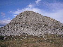 The Truc des Coucuts in Prinsuéjols, a volcanic rock with columnar basalt, which reaches a height of 1,286 m (4,219 ft) | |
 Prinsuéjols Location within Occitanie region  Prinsuéjols | |
| Coordinates: 44°40′31″N 3°10′10″E / 44.6753°N 3.1694°ECoordinates: 44°40′31″N 3°10′10″E / 44.6753°N 3.1694°E | |
| Country | France |
| Region | Occitanie |
| Department | Lozère |
| Arrondissement | Mende |
| Canton | Aumont-Aubrac |
| Area1 | 42.96 km2 (16.59 sq mi) |
| Population (1999)2 | 163 |
| • Density | 3.8/km2 (9.8/sq mi) |
| Time zone | UTC+1 (CET) |
| • Summer (DST) | UTC+2 (CEST) |
| INSEE/Postal code | 48120 /48100 |
| Elevation |
1,084–1,286 m (3,556–4,219 ft) (avg. 1,150 m or 3,770 ft) |
|
1 French Land Register data, which excludes lakes, ponds, glaciers > 1 km2 (0.386 sq mi or 247 acres) and river estuaries. 2 Population without double counting: residents of multiple communes (e.g., students and military personnel) only counted once. | |
Prinsuéjols is a former commune in the Lozère department in southern France. On 1 January 2017, it was merged into the new commune Prinsuéjols-Malbouzon.[1]
See also
References
- ↑ Arrêté préfectoral 3 August 2016 (in French)
| Wikimedia Commons has media related to Prinsuéjols. |
This article is issued from
Wikipedia.
The text is licensed under Creative Commons - Attribution - Sharealike.
Additional terms may apply for the media files.