Prince Christian Sound
| Prince Christian Sound Ikerasassuaq | |
|---|---|
 Prince Christian Sound Location in Greenland | |
| Location | Arctic (S Greenland) |
| Coordinates | 60°9′N 43°53′W / 60.150°N 43.883°WCoordinates: 60°9′N 43°53′W / 60.150°N 43.883°W |
| Ocean/sea sources |
Labrador Sea / Irminger Sea (North Atlantic Ocean) |
| Basin countries | Greenland |
| Max. length | 100 km (62 mi) |
| Max. width | 2.7 km (1.7 mi) |
The Prince Christian Sound (Greenlandic: Ikerasassuaq;[1] Danish:Prins Christians Sund) is a waterway in Southern Greenland. It separates the mainland from Sammisoq (Christian IV Island) and other islands of the Cape Farewell Archipelago near the southernmost tip of Greenland. The name was given in honour of the prince, later king Christian VIII of Denmark.[2]
Geography
The Prince Christian Sound connects the Labrador Sea with the Irminger Sea. It is around 100 km (60 miles) long and it is narrow, sometimes only 500 metres (1,600 ft) wide. There is only one settlement along this sound, Aappilattoq.
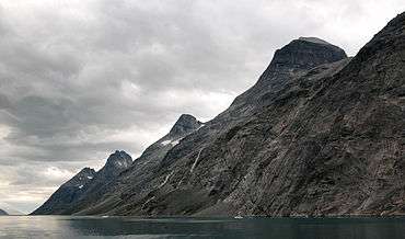
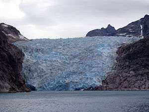
The long fjord system is mostly surrounded by steep mountains reaching over 2,200 metres (7,200 ft) high[3][4] Many glaciers go straight into its waters where they calve icebergs. There are often strong tidal currents limiting the formation of ice. It has many offshoots, such as Kangerluk Fjord to the north midway through the fjord, Ikeq Fjord in the south, and in the west Ilua Fjord, Ikerasaq Fjord (Akuliarutsip Imaa), Utoqqarmiut Fjord (Pamialluup Kujatinngua) and the Torsukattak Fjord.[5]
Tourism
The Prince Christian Sound offers beautiful scenery and several times every summer cruise ships go through this sound, sometimes as large as the Eurodam.[6]
Climate
Prince Christian Sound has a maritime polar climate with low annual temperature swings for its latitude. Summers are way below the tree line requirements, whereas the long winters are comparatively mild for its high latitude. The nearby ice sheet procdues cold air which keeps summer temperatures down.
| Climate data for Prince Christian Sound 1961-1990, extremes 1958-1999 | |||||||||||||
|---|---|---|---|---|---|---|---|---|---|---|---|---|---|
| Month | Jan | Feb | Mar | Apr | May | Jun | Jul | Aug | Sep | Oct | Nov | Dec | Year |
| Record high °C (°F) | 7.5 (45.5) |
9.0 (48.2) |
9.0 (48.2) |
11.6 (52.9) |
14.0 (57.2) |
20.0 (68) |
24.2 (75.6) |
20.9 (69.6) |
20.0 (68) |
14.2 (57.6) |
9.8 (49.6) |
13.4 (56.1) |
24.2 (75.6) |
| Average high °C (°F) | −1.9 (28.6) |
−1.8 (28.8) |
−1.3 (29.7) |
1.5 (34.7) |
4.4 (39.9) |
7.3 (45.1) |
9.8 (49.6) |
9.6 (49.3) |
6.9 (44.4) |
3.5 (38.3) |
0.6 (33.1) |
−0.9 (30.4) |
3.1 (37.7) |
| Average low °C (°F) | −6.2 (20.8) |
−6.3 (20.7) |
−5.9 (21.4) |
−3.5 (25.7) |
−0.6 (30.9) |
1.2 (34.2) |
3.3 (37.9) |
3.3 (37.9) |
1.9 (35.4) |
−0.7 (30.7) |
−3.4 (25.9) |
−5.1 (22.8) |
−1.8 (28.7) |
| Record low °C (°F) | −20.0 (−4) |
−16.0 (3.2) |
−16.9 (1.6) |
−15.2 (4.6) |
−10.2 (13.6) |
−5.5 (22.1) |
−3.6 (25.5) |
−3.5 (25.7) |
−3.2 (26.2) |
−6.9 (19.6) |
−12.0 (10.4) |
−15.3 (4.5) |
−20 (−4) |
| Average precipitation mm (inches) | 262 (10.31) |
246 (9.69) |
205 (8.07) |
227 (8.94) |
175 (6.89) |
136 (5.35) |
129 (5.08) |
173 (6.81) |
233 (9.17) |
219 (8.62) |
227 (8.94) |
251 (9.88) |
2,483 (97.75) |
| Average precipitation days (≥ 1 mm) | 15.9 | 15.6 | 14.1 | 14.2 | 12.5 | 10.0 | 10.5 | 10.4 | 12.7 | 12.7 | 13.0 | 15.1 | 156.7 |
| Average snowy days | 16.6 | 15.8 | 15.0 | 13.6 | 7.8 | 1.8 | 0.2 | 0.1 | 3.0 | 9.1 | 13.5 | 14.6 | 111.1 |
| Source: http://www.dmi.dk/fileadmin/user_upload/Rapporter/TR/2000/tr00-18.pdf | |||||||||||||
See also
References
- ↑ Den grønlandske Lods - Geodatastyrelsen
- ↑ Prins Christian Sund (Den Store Danske Leksikon) (in Danish)
- ↑ Wiles, Andrew (2016). Arctic and Northern Waters (Revised first ed.). St Ives: Imray Laurie Norie & Wilson LTD. p. 224. ISBN 978 184623 828 4.
- ↑ See Open Street Map at 60.3906N, 44.0016W.
- ↑ "Torsukattak". Mapcarta. Retrieved 8 April 2016.
- ↑ Scenic Cruising on Eurodam
External links
