Pré-en-Pail
| Pré-en-Pail | ||
|---|---|---|
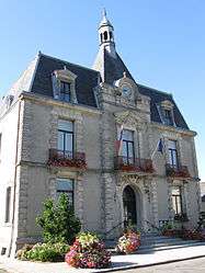 The town hall in Pré-en-Pail | ||
| ||
 Pré-en-Pail Location within Pays de la Loire region  Pré-en-Pail | ||
| Coordinates: 48°27′37″N 0°11′58″W / 48.4603°N 0.1994°WCoordinates: 48°27′37″N 0°11′58″W / 48.4603°N 0.1994°W | ||
| Country | France | |
| Region | Pays de la Loire | |
| Department | Mayenne | |
| Arrondissement | Mayenne | |
| Canton | Villaines-la-Juhel | |
| Government | ||
| • Mayor (2008–2014) | Yves Cortès | |
| Area1 | 44.73 km2 (17.27 sq mi) | |
| Population (2006)2 | 2,120 | |
| • Density | 47/km2 (120/sq mi) | |
| Time zone | UTC+1 (CET) | |
| • Summer (DST) | UTC+2 (CEST) | |
| INSEE/Postal code | 53185 /53140 | |
| Elevation |
174–416 m (571–1,365 ft) (avg. 227 m or 745 ft) | |
|
1 French Land Register data, which excludes lakes, ponds, glaciers > 1 km2 (0.386 sq mi or 247 acres) and river estuaries. 2 Population without double counting: residents of multiple communes (e.g., students and military personnel) only counted once. | ||

Pré-en-Pail is a former commune in the Mayenne department in north-western France. On 1 January 2016, it was merged into the new commune of Pré-en-Pail-Saint-Samson.[1]
See also
| Wikimedia Commons has media related to Pré-en-Pail. |
References
- ↑ Arrêté préfectoral 4 December 2015
This article is issued from
Wikipedia.
The text is licensed under Creative Commons - Attribution - Sharealike.
Additional terms may apply for the media files.