Possession Point
Possession Point (Chinese: 水坑口; Jyutping: seoi2 haang1 hau2) is a former point of land on the northwestern coast of Hong Kong Island in Hong Kong, before land reclamation moved the coast further north.
History
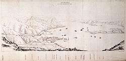
The area is where Commodore James Bremer, commander-in-chief of British forces in China, took formal possession of Hong Kong on 26 January 1841. Captain Edward Belcher, who surveyed the island in 1841, wrote: "We landed on Monday, the 25th, 1841, at fifteen minutes past eight A. M., and being the bona fide first possessors, Her Majesty's health was drank with three cheers on Possession Mount."[1] Accompanied by officers of the naval squadron the next day, Bremer took formal possession, under a feu de joie from the Royal Marines and a royal salute from the men-of-war ships.[1] The hoisting of the Union Jack was possibly done by either William Dowell, who was a midshipman during the ceremony, or Mohammed Arab, who served in either the Bengal Volunteers or 37th Madras Native Infantry.[2]
The area, which came to be known as Possession Point, was kept an open space, and used for recreation by the local Chinese, who called it Tai Tat Tei. It was developed in the 1980s and formed into a hotel and commercial complex, which is also the site of the Hong Kong–Macau Ferry Terminal.[3]
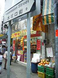
The point has now disappeared from the coastline, but Possession Street and the sudden turn of Queen's Road West reveals its original location. In maps of the 1980s and before, Hollywood Road Park is marked as Possession Point. This marks the original site which, owing to land reclamation, is no longer located on the coast.
The Chinese name, 水坑口 (Shui Hang Hau), means the mouth of water trench, reflecting the mouth of a stream from Victoria Peak.
See also
References
- 1 2 The Chinese Repository. Volume 12. Canton. 1843. p. 492.
- ↑ Lowe, K. J. P. (1989). "Hong Kong, 26 January 1841: Hoisting the Flag Revisited". Journal of the Hong Kong Branch of the Royal Asiatic Society. Volume 29. pp. 13–14.
- ↑ Tsang, Steve (2007) [2004]. A Modern History of Hong Kong. London: I.B. Tauris. p. 16. ISBN 9781845114190.
External links
Coordinates: 22°17′10″N 114°08′55″E / 22.286248°N 114.148621°E