Porto Santo (Madeira)
| Porto Santo | |||
| Vila Baleira | |||
| Municipality (Concelho) | |||
|
|||
| Official name: Concelho do Porto Santo | |||
| Name origin: Portuguese for holy port | |||
| Country | |||
|---|---|---|---|
| Autonomous Region | |||
| Island | Porto Santo | ||
| Center | Farrobo | ||
| - elevation | 92 m (302 ft) | ||
| - coordinates | 33°4′36″N 16°20′40″W / 33.07667°N 16.34444°WCoordinates: 33°4′36″N 16°20′40″W / 33.07667°N 16.34444°W | ||
| Highest point | Pico do Castelo | ||
| - elevation | 402 m (1,319 ft) | ||
| Lowest point | |||
| - elevation | 0 m (0 ft) | ||
| Area | 42.59 km2 (16 sq mi) | ||
| Population | 5,483 (2011) | ||
| Density | 129/km2 (334/sq mi) | ||
| Settlement | fl. 1500 | ||
| - Municipality | c. 1835 | ||
| - Vila/Town | 6 August 1996 | ||
| LAU | Câmara Municipal | ||
| - location | Rua Dr. Nuno Silvestre Texeira | ||
| President | Filipe Oliveira de Menezes | ||
| Municipal Chair | Maria Luísa de Sousa M.G. Mendonça | ||
| Timezone | WET (UTC0) | ||
| - summer (DST) | WEST (UTC+1) | ||
| Postal Zone | 9400-000 | ||
| Area Code & Prefix | (+351) 291 XXX XXX | ||
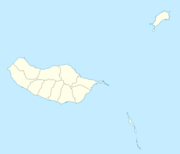 Location of the municipality of Porto Santo, in the archipelago of Madeira | |||
| Website: www | |||


Porto Santo is the only municipality of the island of Porto Santo, in the Portuguese Madeiran archipelago. It was elevated to city status on 6 August 1996. The only parish of the municipality is also named Porto Santo. The population in 2011 was 5,483,[1] in an area of 42.59 km².[2] The main settlement on the island is Vila Baleira.
Climate
| Climate data for Porto Santo Island | |||||||||||||
|---|---|---|---|---|---|---|---|---|---|---|---|---|---|
| Month | Jan | Feb | Mar | Apr | May | Jun | Jul | Aug | Sep | Oct | Nov | Dec | Year |
| Average high °C (°F) | 17 (63) |
17 (63) |
18 (64) |
18 (65) |
19 (67) |
21 (70) |
23 (73) |
25 (77) |
25 (77) |
22 (72) |
20 (68) |
18 (65) |
21 (69) |
| Average low °C (°F) | 14 (57) |
14 (57) |
14 (57) |
14 (58) |
16 (60) |
18 (64) |
19 (67) |
23 (73) |
23 (73) |
19 (66) |
17 (62) |
16 (60) |
17 (62) |
| Average precipitation mm (inches) | 56 (2.2) |
43 (1.7) |
43 (1.7) |
23 (0.9) |
13 (0.5) |
5 (0.2) |
3 (0.1) |
5 (0.2) |
23 (0.9) |
46 (1.8) |
64 (2.5) |
53 (2.1) |
378 (14.9) |
| Source: Weatherbase [3] | |||||||||||||
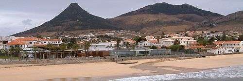
Vila Baleira, Porto Santo's capital
References
- ↑ Instituto Nacional de Estatística
- ↑ Eurostat
- ↑ "Weatherbase: Historical Weather for Porto Santo Island, Portugal". Weatherbase. 2011. Retrieved on November 24, 2011.
External links

This article is issued from
Wikipedia.
The text is licensed under Creative Commons - Attribution - Sharealike.
Additional terms may apply for the media files.