Portaria
| Portaria Πορταριά | |
|---|---|
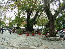 Portaria square | |
 Portaria Location within the regional unit 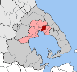 | |
| Coordinates: 39°23′N 23°0′E / 39.383°N 23.000°ECoordinates: 39°23′N 23°0′E / 39.383°N 23.000°E | |
| Country | Greece |
| Administrative region | Thessaly |
| Regional unit | Magnesia |
| Municipality | Volos |
| • Municipal unit | 22.8 km2 (8.8 sq mi) |
| Elevation | 600 m (2,000 ft) |
| Population (2011)[1] | |
| • Municipal unit | 1,911 |
| • Municipal unit density | 84/km2 (220/sq mi) |
| Time zone | UTC+2 (EET) |
| • Summer (DST) | UTC+3 (EEST) |
| Postal code | 370 11 |
| Area code(s) | 24280 |
| Vehicle registration | ΒΟ |
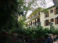
Portaria (Greek: Πορταριά) is a village and a former municipality in Magnesia, Thessaly, Greece. Since the 2011 local government reform it is part of the municipality Volos, of which it is a municipal unit.[2] The municipal unit has an area of 22.754 km2.[3] It is located on Mt. Pelion, facing the Pagasetic Gulf, north of Volos and its suburbs. The majority of the buildings are typical examples of Pelion architecture with their windows and doors decorated with a variety of colors. The mountaintop of Pelion is to the north.
Portaria
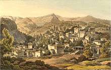
Portaria, c.1820
Historical population
| Year | Village population | Municipality population |
|---|---|---|
| 1981 | 769 | - |
| 1991 | 1,093 | 3,318 |
| 2001 | 1,327 | 3,201 |
| 2011 | 566 | 1,911 |
Sister cities
See also
References
- ↑ "Απογραφή Πληθυσμού - Κατοικιών 2011. ΜΟΝΙΜΟΣ Πληθυσμός" (in Greek). Hellenic Statistical Authority.
- ↑ Kallikratis law Greece Ministry of Interior (in Greek)
- ↑ "Population & housing census 2001 (incl. area and average elevation)" (PDF) (in Greek). National Statistical Service of Greece.
External links
Neighboring localities
Places adjacent to Portaria | ||||||||||
|---|---|---|---|---|---|---|---|---|---|---|
| ||||||||||
This article is issued from
Wikipedia.
The text is licensed under Creative Commons - Attribution - Sharealike.
Additional terms may apply for the media files.