Port Mayaca Lock and Dam
| Port Mayaca Lock and Dam | |
|---|---|
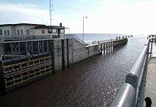 View through open lakeside gates of the Port Mayaca Navigational Lock, onto Lake Okeechobee. | |
| Official name | Port Mayaca Lock and Dam |
| Location |
|
| Opening date | 1977 |
| Construction cost | $13,100,000 |
| Dam and spillways | |
| Height | unlimited |
| Length | 400 feet |
| Width (base) | 56 feet |
The Port Mayaca Lock is a navigable lock and dam on the Okeechobee Waterway (St. Lucie Canal), adjacent to U.S. Route 441 and U.S. Route 98 at Canal Point, in Martin County, Florida, United States.[1]
It is located near Port Mayaca at latitude 26° 59" 5', longitude -80° 37" 5'.[2]
Port Mayaca Lock is open daily from 7:00am to 5:00pm. New Lock hour as of 1 April 2015.[3]
The total cost of construction was $13.1 million.[3]
Purpose
This structure was created to help raise the water level in the lake, for the purpose of retaining fresh water for agricultural use, city water supply, and for navigation. It also serves for regulating flood control water into the Everglades during hurricane season.[4]
Technical information
The lock chamber is 56 feet (17 m) wide by 400 feet (120 m) long, and 14 feet (4.3 m) deep. The lift distance between the St. Lucie Canal and Lake Okeechobee is normally 1/2 to 2 feet (0.61 m). The channel width is 100 feet (30 m), and 8 feet (2.4 m) deep.[3]
The lock gates are "sector gates" (pie-slice shaped), and are made of steel. The spillway is ogee-type concrete, with 4 vertical lift gates.[3]
The discharge capacity is 14,800 cubic feet per second (420 m3/s).[3]
Radio channel
This lock operates on Marine VHF radio channel 13.[3]
Gallery
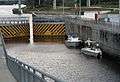 Boaters anchored lock wall as the canal-side gates close.
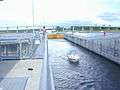 Boater exits as canal-side gates closed behind and Lake Okeechobee lakeside gates opening.
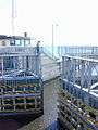 U.S. Army Corps of Engineer personnel overlooks the closing of the lakeside gates.
 Canal 59 in the foreground and Control Structure S-191, which controls water flow into Lake Okeechobee.
See also
References
- ↑ "New Port Mayaca Lock FL" (PDF). Archived from the original (PDF) on 2006-09-27. Retrieved 2010-08-25.
- ↑ "Port Mayaca Lock - Florida, United States". Marinas.com. Retrieved 2010-08-25.
- 1 2 3 4 5 6 "Archived copy" (PDF). Archived from the original (PDF) on 2011-07-25. Retrieved 2010-08-25.
- ↑ American Canal Society Report Archived 2006-09-27 at the Wayback Machine.
External links
Coordinates: 26°59′04″N 80°37′16″W / 26.984531°N 80.621105°W