Porquerolles
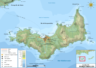
Coordinates: 43°00′N 6°13′E / 43.000°N 6.217°E Porquerolles (French pronunciation: [pɔʁkəʁɔl]), also known as the Île de Porquerolles, is an island in the Îles d'Hyères, Var, Provence-Alpes-Côte d'Azur, France. Its land area is 1,254 hectares (12.54 km2; 4.84 sq mi) and in 2004 its population was about 200.
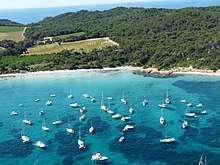
Porquerolles is the largest, most westerly of the three Îles d'Hyères. It is about 7 km (4.3 miles) long by 3 km (1.9 miles) wide, with five small ranges of hills. The south coast is lined with cliffs, and on the north coast are the port and the beaches of Notre Dame, La Courtade, and Plage d'Argent.
History
The island's village was established in 1820, with its lighthouse constructed in 1837 and church in 1850. The entire island was purchased in 1912 by François Joseph Fournier, apparently as a wedding present for his wife; he planted 200 hectares (500 acres) of vineyards which produced a wine that was among the first to be classified as vin des Côtes de Provence.
In 1971 the state bought 80 percent of the island to preserve it from development. Much of the island is now part of a national park (the Port-Cros Parc National) and nature conservation area (Conservatoire botanique national méditerranéen de Porquerolles).
It is the setting for Georges Simenon's novels, "Le Cercle de Mahe" ("The Mahe Circle") (1946) and Mon Ami Maigret (My Friend Maigret) (1949) and for the 1964 novel Valparaiso by Nicolas Freeling.
Since 2010, the island also hosts a jazz festival each summer ("Jazz à Porquerolles").
On December 28, 2016 Var Martin reported that residents were considering blockading the port to protest the closure of the post office and the police station.
Climate
| Climate data for Porquerolles (1981–2010 averages, extremes 1949–present) | |||||||||||||
|---|---|---|---|---|---|---|---|---|---|---|---|---|---|
| Month | Jan | Feb | Mar | Apr | May | Jun | Jul | Aug | Sep | Oct | Nov | Dec | Year |
| Record high °C (°F) | 20.0 (68) |
22.0 (71.6) |
23.5 (74.3) |
26.8 (80.2) |
30.6 (87.1) |
34.1 (93.4) |
37.0 (98.6) |
38.5 (101.3) |
33.1 (91.6) |
29.2 (84.6) |
24.8 (76.6) |
22.5 (72.5) |
38.5 (101.3) |
| Average high °C (°F) | 12.9 (55.2) |
13.1 (55.6) |
15.5 (59.9) |
17.4 (63.3) |
21.6 (70.9) |
25.3 (77.5) |
28.2 (82.8) |
28.5 (83.3) |
25.3 (77.5) |
21.0 (69.8) |
16.2 (61.2) |
13.3 (55.9) |
19.9 (67.8) |
| Daily mean °C (°F) | 10.0 (50) |
10.0 (50) |
12.0 (53.6) |
13.8 (56.8) |
17.7 (63.9) |
21.1 (70) |
24.0 (75.2) |
24.3 (75.7) |
21.4 (70.5) |
17.8 (64) |
13.3 (55.9) |
10.7 (51.3) |
16.4 (61.5) |
| Average low °C (°F) | 7.2 (45) |
6.8 (44.2) |
8.5 (47.3) |
10.2 (50.4) |
13.8 (56.8) |
17.0 (62.6) |
19.7 (67.5) |
20.1 (68.2) |
17.5 (63.5) |
14.6 (58.3) |
10.4 (50.7) |
8.0 (46.4) |
12.9 (55.2) |
| Record low °C (°F) | −7.0 (19.4) |
−10.0 (14) |
−5.8 (21.6) |
2.0 (35.6) |
6.4 (43.5) |
9.0 (48.2) |
10.2 (50.4) |
11.5 (52.7) |
10.0 (50) |
3.5 (38.3) |
−1.2 (29.8) |
−2.0 (28.4) |
−10.0 (14) |
| Average precipitation mm (inches) | 64.9 (2.555) |
45.9 (1.807) |
40.3 (1.587) |
61.3 (2.413) |
36.5 (1.437) |
28.9 (1.138) |
7.7 (0.303) |
16.4 (0.646) |
57.8 (2.276) |
91.0 (3.583) |
77.0 (3.031) |
68.5 (2.697) |
596.2 (23.472) |
| Average precipitation days (≥ 1.0 mm) | 6.0 | 5.1 | 4.2 | 6.9 | 4.0 | 2.8 | 0.8 | 1.8 | 4.3 | 6.9 | 6.8 | 7.2 | 56.8 |
| Source: Meteo France[1] | |||||||||||||
Points of interest
References
- ↑ "Porquerolles (83)" (PDF). Fiche Climatologique: Statistiques 1981–2010 et records (in French). Meteo France. Archived from the original (PDF) on 5 April 2018. Retrieved 5 April 2018.
| Wikivoyage has a travel guide for Porquerolles. |
| Wikimedia Commons has media related to Porquerolles. |
- ProvenceWeb: Ile de Porquerolles
- Porquerolles - office de tourisme la londe les maures
- Porquerolles.com description
- Port-Cros Parc National