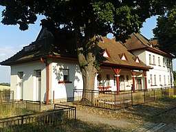
Poriadie
| Poriadie | |
| Village | |
 Railway station | |
| Country | Slovakia |
|---|---|
| Region | Trenčín |
| District | Myjava |
| Elevation | 425 m (1,394 ft) |
| Coordinates | 48°46′32″N 17°36′31″E / 48.77556°N 17.60861°ECoordinates: 48°46′32″N 17°36′31″E / 48.77556°N 17.60861°E |
| Area | 7.872 km2 (3.04 sq mi) |
| Population | 695 |
| Density | 88/km2 (228/sq mi) |
| First mentioned | 1955 |
| Postal code | 916 16 |
| Car plate | MY |
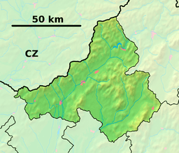 Location of Poriadie in the Trenčín Region  Poriadie (Slovakia) | |
| Wikimedia Commons: Poriadie | |
| Website: www.poriadie.sk | |
Poriadie (Hungarian: Erdősor) is a village and municipality in Myjava District in the Trenčín Region of north-western Slovakia.
History
In historical records the village was first mentioned in 1955.
Geography
The municipality lies at an altitude of 425 metres and covers an area of 7.872 km². It has a population of about 695 people.
External links
Municipalities of Myjava District | ||
|---|---|---|
This article is issued from
Wikipedia.
The text is licensed under Creative Commons - Attribution - Sharealike.
Additional terms may apply for the media files.