Ponte della Libertà
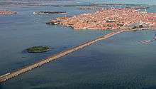
Ponte della Libertà[1] ("Bridge of Liberty") is a road bridge connecting the historical centre (islands) of the city of Venice to the mainland part of Venice.
Designed in 1932 by engineer Eugenio Miozzi, it was opened by Benito Mussolini in 1933 as Ponte Littorio ("lictor's bridge") – a name used during the Fascist era for several other Italian bridges. At the end of World War II it was renamed Ponte della Libertà to honour the end of the Fascist dictatorship and of the Nazi occupation.
The bridge is the only vehicular access to the historical centre of the capital city of the Italian region of Veneto.
- The eastern end of the road terminates in the Piazzale Roma, the bus depot of the historical centre.
- The western end reaches mainland Venice and becomes the Via Libertà, which divides the Venetian boroughs (municipalità) of Mestre (north) and Marghera (south). It is final section of the old Public Road 11, "Padana Superiore".
It is 3.85 km (2.39 mi) long and has two lanes each way, with no emergency lane. It is built alongside the Venice Railroad Bridge,[2] which was constructed in 1846, with two tracks each way, and is still in use.
References
- ↑ "Ponte della Libertà". Structurae, Germany. Retrieved August 26, 2011.
- ↑ Venice Railroad Bridge
Coordinates: 45°27′10.89″N 12°17′58.49″E / 45.4530250°N 12.2995806°E