Ponta Preta (Maio)
| Ponta Preta | |
|---|---|
 | |
| Location | Southwestern Maio, Cape Verde |
| Coordinates | 15°07′41″N 23°12′25″W / 15.128°N 23.207°WCoordinates: 15°07′41″N 23°12′25″W / 15.128°N 23.207°W |
| Offshore water bodies | Atlantic Ocean |
Ponta Preta (Portuguese meaning the black point) is a headland located in the southwest of the island of Maio, Cape Verde. It is 1 km southeast of the town Porto Inglês.
The island of Maio | ||
|---|---|---|
| Communities and settlements | 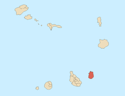 | |
| Mountains | ||
| Other geographical features | ||
This article is issued from
Wikipedia.
The text is licensed under Creative Commons - Attribution - Sharealike.
Additional terms may apply for the media files.