Poniatowice
| Poniatowice | |
|---|---|
| Village | |
 Poniatowice | |
| Coordinates: 51°14′N 17°33′E / 51.233°N 17.550°E | |
| Country |
|
| Voivodeship | Lower Silesian |
| County | Oleśnica |
| Gmina | Gmina Oleśnica |
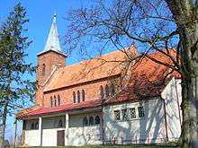
Church in Poniatowice
Poniatowice [pɔɲatɔˈvit͡sɛ] (German: Pontwitz) is a village in the administrative district of Gmina Oleśnica, within Oleśnica County, Lower Silesian Voivodeship, in south-western Poland.[1] Prior to 1945 it was in Germany.
It lies approximately 13 kilometres (8 mi) east of Oleśnica, and 38 kilometres (24 mi) east of the regional capital Wrocław.
References
| Villages | ||
|---|---|---|
| Seat (not part of the gmina) | ||
This article is issued from
Wikipedia.
The text is licensed under Creative Commons - Attribution - Sharealike.
Additional terms may apply for the media files.