Pongaroa
Coordinates: 40°33′S 176°11′E / 40.550°S 176.183°E
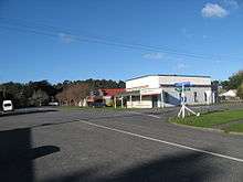
Pongaroa is a town in the Tararua District, in the southeast of the North Island of New Zealand, 110 kilometres southwest of Hastings and 200 kilometres northeast of Wellington. The nearest town is Pahiatua, 50 kilometres to the west. Popular Akitio Beach is 30 kilometres to the east. The township straddles Route 52, a road between Masterton and Waipukurau.
Pongaroa village has a population of about 100, with the surrounding farms bringing the total population to about 300. The area is serviced by Pongaroa School, Pongaroa Cafe and General Store, Pongaroa Hotel, and Pongaroa Farm Centre.[1] Pongaroa is also the location of the New Zealand Centre for Equine Psychology and Behaviour[2] and Wildside Farm environmental education retreat.[3]
As a rural community, Pongaroa relies on community spirit and on the local community-development organisation "Pongaroa The Way To Go". Volunteers have been central to improvements in the area, such as the installation of public toilets, the establishment of a freedom campsite and the enhancement of the village centre.[4]
Historically, Pongaroa belonged in the northern Wairarapa area. At one time during the early settlement years in the latter half of the 19th century, the township was much larger: people expected that the Masterton-Napier Railway would run through Pongaroa. However, eventually the Wairarapa Line cut through Pahiatua (1897) and thus that township grew, whilst Pongaroa remained a farming community. Pongaroa became an administrative centre of Akitio County, which functioned between 1899 and 1976.[5]
Pāpāuma marae, a marae (tribal meeting ground) of the Rangitāne tribes and its Ngāti Mutuahi, Ngāti Pakapaka and Te Hika a Pāpāuma hapū (sub-tribes), is located in the Pangaoroa area.[6] It includes Te Aroha o Aohanga wharenui (meeting house), also known as Pāpāuma.[7]
Notable people
- Maurice Wilkins (1916-2004), scientist
References
- ↑ http://www.pongaroa.school.gen.nz
- ↑ http://www.herdword.co.nz
- ↑ http://www.wildsidefarm.co.nz
- ↑ http://www.pongaroathewaytogo.org.nz
- ↑ http://archivescentral.org.nz/agencies/topics/show/76757-akitio-county-council
- ↑ "Te Kāhui Māngai directory". tkm.govt.nz. Te Puni Kōkiri.
- ↑ "Māori Maps". maorimaps.com. Te Potiki National Trust.