Pomponio Creek
| Pomponio Creek | |
| Cañada de la La Salud[1][2] | |
| stream | |
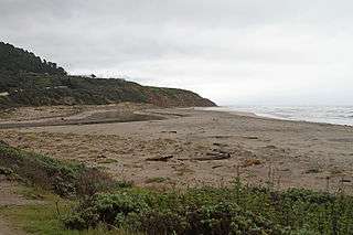 The mouth of Waddell Creek at Waddell Beach, in the Rancho Del Oso section of the Big Basin Redwoods State Park | |
| Country | United States |
|---|---|
| State | California |
| Region | Santa Clara County |
| Tributaries | |
| - left | East Waddell Creek |
| - right | West Waddell Creek |
| Source | Confluence of East and West Waddell Creeks in the |
| - location | Big Basin Redwoods State Park |
| - elevation | 962 ft (293 m) [3] |
| - coordinates | 37°17′49″N 122°18′12″W / 37.29694°N 122.30333°W [4] |
| Mouth | Pacific Ocean |
| - elevation | 0 ft (0 m) [4] |
| - coordinates | 37°17′53″N 122°24′21″W / 37.29806°N 122.40583°WCoordinates: 37°17′53″N 122°24′21″W / 37.29806°N 122.40583°W [4] |
Pomponio Creek is a 7.2 miles (11.6 km) westward flowing stream in San Mateo County, California that originates on the western slope of the Santa Cruz Mountains and flows into the Pacific Ocean at Pomponio State Beach.[3]
History
Pomponio Creek is named for Ponponio Lupugeyun (also known as José Pomponio Lupugeym), a resistance fighter against the California mission system who had a mountain hideout at the headwaters of Pomponio Creek.[5]
Watershed and Course
A dam forms Pomponio Reservoir is located at about 6.2 miles (10.0 km) upstream from the mouth.[6]
Ecology
A 15 foot high bedrock waterfall located about 2.3 miles (3.7 km) upstream from the creek mouth is an impassible barrier for immigrating steelhead trout (Oncorhynchus mykiss).[6] In 2004, the private, nonprofit Peninsula Open Space Trust (POST) purchased conservation easements on the Arata Ranch along Pomponio Creek to protect the watershed.[7]
References
- ↑ Erwin Gustav Gudde (1960). California Place Names: The Origin and Etymology of Current Geographical Names. University of California Press. p. 356. GGKEY:403N5Z6QERG.
- ↑ Donald Thomas Clark (1986). Santa Cruz County Place Names. Santa Cruz: Santa Cruz Historical Society.
- 1 2 U.S. Geological Survey. National Hydrography Dataset high-resolution flowline data. The National Map, accessed March 5, 2017
- 1 2 3 "Pomponio Creek". Geographic Names Information System. United States Geological Survey.
- ↑ William Bright (30 November 1998). 1500 California Place Names: Their Origin and Meaning, A Revised version of 1000 California Place Names by Erwin G. Gudde, Third edition. University of California Press. pp. 118–. ISBN 978-0-520-92054-5.
- 1 2 Steelhead/rainbow trout resources of San Mateo County (PDF) (Report). Retrieved March 5, 2017.
- ↑ John Hart (January 1, 2006). "San Mateo Coast, Pumpkins and Post Preserving the Coast". Retrieved March 5, 2017.