Polenz
| Polenz | |
|---|---|
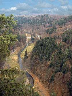 The Polenz valley immediately above the Lusatian Fault | |
| Country | Germany |
| Physical characteristics | |
| Main source |
in Saxony ca. 380 m above sea level (NN) |
| River mouth |
confluence with the Sebnitz at Lachsbach near Porschdorf ca. 150 m above sea level (NN) 50°56′35″N 14°08′06″E / 50.943148°N 14.135120°E |
| Length | 31.3 km [1] |
| Discharge |
|
| Basin features | |
| Progression | Lachsbach→ Elbe→ North Sea |
| Basin size | 104 km² [1] |
| Landmarks |
|
| Navigable | nein |
The Polenz is the right-hand, smaller headstream of the Lachsbach in the German state of Saxony. Its lower course flows through the western Elbe Sandstone Mountains in a canyon-like valley.
Geography
The Polenz rises from nine springs on the German-Czech border between the villages of Langburkersdorf and Nová Víska (Neudörfel). The springs are located southwest of the 461 m high Roubený (Raupenberg) mainly on German territory and unite at a height of 363 m above sea level. The upper reaches of the Polenz form the natural boundary between the Hohwald and Saxon Switzerland.
Tributaries
The most important tributaries of the Polenz are the:
- Laubbach, Langburkersdorf
- Schluckenbach, Neustadt in Sachsen
- Lohbach, Neustadt in Sachsen
- Flemigbach, Polenz
- Rückersdorfer Bach, below Polenz
- Cunnersdorfer Bach, by the Bock Mill
- Goldflüßchen, at the Heeselicht Mill
- Bärenhohlflüßchen, above the Rußig Mill
- Schindergraben, at Hockstein
- Tiefergrundbach, at the Frinzthal Mill
References
External links

This article is issued from
Wikipedia.
The text is licensed under Creative Commons - Attribution - Sharealike.
Additional terms may apply for the media files.