Point cloud
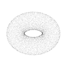
A point cloud is a set of data points in space. Point clouds are generally produced by 3D scanners, which measure a large number of points on the external surfaces of objects around them. As the output of 3D scanning processes, point clouds are used for many purposes, including to create 3D CAD models for manufactured parts, for metrology and quality inspection, and for a multitude of visualization, animation, rendering and mass customization applications.
Alignment and registration
Point clouds are often aligned with 3D models or with other point clouds, a process known as point set registration.
For industrial metrology or inspection using industrial computed tomography, the point cloud of a manufactured part can be aligned to an existing model and compared to check for differences. Geometric dimensions and tolerances can also be extracted directly from the point cloud.
Conversion to 3D surfaces
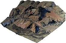
While point clouds can be directly rendered and inspected,[3][4] point clouds are often converted to polygon mesh or triangle mesh models, NURBS surface models, or CAD models through a process commonly referred to as surface reconstruction.
There are many techniques for converting a point cloud to a 3D surface.[5] Some approaches, like Delaunay triangulation, alpha shapes, and ball pivoting, build a network of triangles over the existing vertices of the point cloud, while other approaches convert the point cloud into a volumetric distance field and reconstruct the implicit surface so defined through a marching cubes algorithm.[6]
In geographic information systems, point clouds are one of the sources used to make digital elevation model of the terrain.[7] They are also used to generate 3D models of urban environments.[8]
Point clouds can also be used to represent volumetric data, as is sometimes done in medical imaging. Using point clouds, multi-sampling and data compression can be achieved.[9]
See also
- Euclideon, a 3D graphics engine which makes use of a point cloud search algorithm to render images.
- MeshLab, an open source tool for managing point clouds and converting them into 3D triangular meshes;
- CloudCompare, an open source tool for viewing, editing and processing high density 3D point clouds
- PCL (Point Cloud Library), a comprehensive BSD open source library for n-D Point Clouds and 3D geometry processing
- List of programs for point cloud processing
References
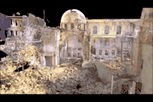
- ↑ Patrimoine, Art Graphique & (2017-11-02), English: Image from a very high precision 3D laser scanner survey (1.2 billion data points) of Beit Ghazaleh -- a heritage site in danger in Aleppo Syria. This was a collaborative scientific work for the study, safeguarding and emergency consolidation of remains of the structure., retrieved 2018-06-11
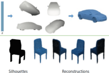
- ↑ "Soltani, A. A., Huang, H., Wu, J., Kulkarni, T. D., & Tenenbaum, J. B. Synthesizing 3D Shapes via Modeling Multi-View Depth Maps and Silhouettes With Deep Generative Networks. In Proceedings of the IEEE Conference on Computer Vision and Pattern Recognition (pp. 1511-1519)".
- ↑ Levoy, M. and Whitted, T., "The use of points as a display primitive". . Technical Report 85-022, Computer Science Department, University of North Carolina at Chapel Hill, January, 1985
- ↑ Rusinkiewicz, S. and Levoy, M. 2000. QSplat: a multiresolution point rendering system for large meshes. In Siggraph 2000. ACM , New York, NY, 343–352. DOI= http://doi.acm.org/10.1145/344779.344940
- ↑ Berger, M., Tagliasacchi, A., Seversky, L. M., Alliez, P., Guennebaud, G., Levine, J. A., Sharf, A. and Silva, C. T. (2016), A Survey of Surface Reconstruction from Point Clouds. Computer Graphics Forum.
- ↑ Meshing Point Clouds A short tutorial on how to build surfaces from point clouds
- ↑ From Point Cloud to Grid DEM: A Scalable Approach
- ↑ K. Hammoudi, F. Dornaika, B. Soheilian, N. Paparoditis. Extracting Wire-frame Models of Street Facades from 3D Point Clouds and the Corresponding Cadastral Map. International Archives of Photogrammetry, Remote Sensing and Spatial Information Sciences (IAPRS), vol. 38, part 3A, pp. 91–96, Saint-Mandé, France, 1–3 September 2010.
- ↑ Sitek; et al. (2006). "Tomographic Reconstruction Using an Adaptive Tetrahedral Mesh Defined by a Point Cloud". IEEE Trans. Med. Imag. 25: 1172. doi:10.1109/TMI.2006.879319.