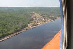
Podkamennaya Tunguska River
| Podkamennaya Tunguska | |
|---|---|
 | |
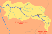 Map of the Yenisei basin that shows the Podkamennaya Tunguska river | |
| Country | Russia |
| Physical characteristics | |
| River mouth | Yenisei River |
| Length | 1,865 km (1,159 mi) |
| Discharge |
|
| Basin features | |
| Basin size | 240,000 km2 (93,000 sq mi) |
The Podkamennaya Tunguska (Russian: Подкаменная Тунгуска, literally Tunguska under the stones, also Middle Tunguska or Stony Tunguska) is a river in Krasnoyarsk Krai, Russia. It is an eastern tributary of the Yenisei and has a length of 1,160 miles (1,870 km). The name of the river comes from the fact that it flows under pebble fields without open water. As early as 1610 Russians from Mangazeya had passed the Stony Tunguska's confluence with the Yenisei; by the 1620s Mangazeya Cossacks and trappers had ascended it seeking fur-tribute from the local Tungus clans.[1][2] The Tunguska event in June 1908 occurred near this river, some 8 km (5.0 mi) SSE of Lake Cheko.
In its upper reaches the river is known as Katanga.[3]
References
- ↑ Fisher, Raymond Henry (1943). The Russian Fur Trade, 1550–1700. University of California Press.
- ↑ Forsyth, James (1992). A History of the Peoples of Siberia: Russia's North Asian colony 1581–1990. Cambridge: Cambridge University Press.
- ↑ Тунгуска/ Great Soviet Encyclopedia
Coordinates: 61°35′40″N 90°08′00″E / 61.5944°N 90.1333°E