Pobershau
| Pobershau | ||
|---|---|---|
| Ortsteil of Marienberg | ||
 Pobershau | ||
| ||
 Pobershau | ||
| Coordinates: 50°38′N 13°13′E / 50.633°N 13.217°ECoordinates: 50°38′N 13°13′E / 50.633°N 13.217°E | ||
| Country | Germany | |
| State | Saxony | |
| District | Erzgebirgskreis | |
| Town | Marienberg | |
| Area | ||
| • Total | 5.41 km2 (2.09 sq mi) | |
| Elevation | 550 m (1,800 ft) | |
| Population (2010-12-31) | ||
| • Total | 2,014 | |
| • Density | 370/km2 (960/sq mi) | |
| Time zone | CET/CEST (UTC+1/+2) | |
| Postal codes | 09496 | |
| Dialling codes | 03735 | |
| Vehicle registration | ERZ | |
| Website | www.pobershau.de | |

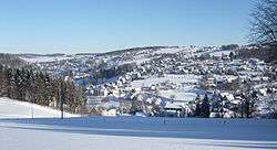
Pobershau is a former municipality in the district Erzgebirgskreis, in Saxony, Germany. With effect from 1 January 2012, it has been incorporated into the town of Marienberg.[1]
Geography
Pobershau lies in the valley of the Red Pockau, a tributary of the Black Pockau. The hamlet of Rittersberg lies north of the main village on the left slopes of the Red Pockau. The hamlet of Hinterer Grund lie east of the village rather remotely in the valley of the Black Pockau. The highest point in Pobershaus lies at 700.5 m above NHN near the Katzensteine mountain. The lowest point is at 500 m above NHN in the Kniebreche, the area around the confluence of the Red and Black Pockau.
Subdivisions
The municipality is divided into:
- Pobershau
- Rittersberg
References
- ↑ Media service of the State of Saxony, retrieved 2012-01-02
| Wikimedia Commons has media related to Pobershau. |
This article is issued from
Wikipedia.
The text is licensed under Creative Commons - Attribution - Sharealike.
Additional terms may apply for the media files.