Plum Trees, Oregon
| Plum Trees | |
|---|---|
| Unincorporated community | |
 Plum Trees  Plum Trees | |
| Coordinates: 42°48′50″N 124°21′24″W / 42.81389°N 124.35667°WCoordinates: 42°48′50″N 124°21′24″W / 42.81389°N 124.35667°W | |
| Country | United States |
| State | Oregon |
| County | Curry |
| Elevation | 217 ft (66 m) |
| Time zone | UTC-8 (Pacific (PST)) |
| • Summer (DST) | UTC-7 (PDT) |
| GNIS feature ID | 1147806[1] |
| Coordinates and elevation from Geographic Names Information System[1] | |
Plum Trees is an unincorporated community in Curry County, Oregon, United States.[1] It lies along the Sixes River, about 16 miles (26 km) upstream of its mouth on the Pacific Ocean near Cape Blanco.[2] Sixes River Road runs by Plum Trees, which is adjacent to the Rogue River – Siskiyou National Forest slightly north of Grassy Knob Wilderness in the Klamath Mountains.[3]
References
- 1 2 3 "Plum Trees". Geographic Names Information System. United States Geological Survey. November 28, 1980. Retrieved January 5, 2017.
- ↑ "Sixes River" (Map). ACME Mapper 2.1. ACME Labs. Retrieved January 5, 2017.
- ↑ Oregon Atlas & Gazetteer (7th ed.). Yarmouth, Maine: DeLorme. 2008. p. 58. ISBN 0-89933-347-8.
Municipalities and communities of Curry County, Oregon, United States | ||
|---|---|---|
| Cities | 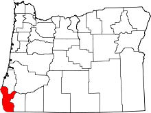 | |
| CDPs | ||
| Other unincorporated communities | ||
| Indian reservation | ||
| Footnotes | ‡This populated place also has portions in an adjacent county or counties | |
This article is issued from
Wikipedia.
The text is licensed under Creative Commons - Attribution - Sharealike.
Additional terms may apply for the media files.