Plettenberg
| Plettenberg | ||
|---|---|---|
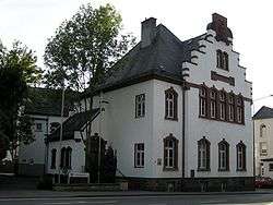 District courthouse in Plettenberg | ||
| ||
 Plettenberg Location of Plettenberg within Märkischer Kreis district 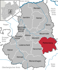  | ||
| Coordinates: 51°13′N 07°53′E / 51.217°N 7.883°ECoordinates: 51°13′N 07°53′E / 51.217°N 7.883°E | ||
| Country | Germany | |
| State | North Rhine-Westphalia | |
| Admin. region | Arnsberg | |
| District | Märkischer Kreis | |
| Government | ||
| • Mayor | Klaus Müller (SPD) | |
| Area | ||
| • Total | 96.29 km2 (37.18 sq mi) | |
| Elevation | 194 - 593 m (−1,752 ft) | |
| Population (2016-12-31)[1] | ||
| • Total | 25,528 | |
| • Density | 270/km2 (690/sq mi) | |
| Time zone | CET/CEST (UTC+1/+2) | |
| Postal codes | 58840 | |
| Dialling codes | 02391 | |
| Vehicle registration | MK | |
| Website | www.plettenberg.de | |

Plettenberg is a town in the Märkischer Kreis, in North Rhine-Westphalia, Germany.
Geography
Plettenberg is located to the east of the Sauerland hills. The highest elevation of the city area is in the Ebbegebirge with 663 m above sea level, the lowest elevation with 194 m near Teindeln. The city is spread out between the four valleys of the rivers Lenne, Else, Oester and Grüne.
Division of the town
Plettenberg consists of 5 districts:
- Plettenberg (city center) (14,012 inhabitants)
- Eiringhausen (4,905 inhabitants)
- Holthausen/upper Elsetal (3,985 inhabitants)
- Oestertal (3,055 inhabitants)
- Ohle (2,825 inhabitants)
History
Probably the first written proof of Plettenberg was made in a document from Grafschaft Abbey of Anno II, archbishop of Cologne, at that time named Heslipho. The name was later changed to Plettenberg, as the name of the noble family von Plettenberg, who owned virtually all of the city and surrounding lands.
The Dukes of the Mark bought the town from Cologne, who in 1301 built the castle Schwarzenberg (which was destroyed by fire in 1864). In 1387, Count Engelbert III granted the town some privileges, it received full city rights in 1397 from Count Dietrich von der Mark. At the same time, the city was fortified. The city blossomed in the following centuries thanks to mining and iron casting, as well as trading with the Hanseatic League.
In 1941, the city was enlarged to its current size, when the former city and the surrounding Amt were merged.
Population development
|
|
|
|
The number of inhabitants till 1933 is the core city, since 1998 with the incorporated districts.
Mayors
- 1902–1924: Rudolf Emil Gottlob Köhler
- 1925–1930: Ludwig Schneider
- 1934–1938: Engelbert Wahle
- 1945–1948: Wilhelm Ding (SPD)
- 1948–1951: Karl Halfmann (CDU)
- 1951–1954: Emil Arndt (SPD)
- 1954–1956: Paul Thomee (FDP)
- 1956–1960: Heinz Chmill (SPD)
- 1960–1964: Wilhelm Wicker (CDU)
- 1964–1983: Heinz Baberg (SPD)
- 1984–1986: Udo Scheepers (SPD)
- 1986–1999: Otto Klehm (SPD)
- 1999–2004: Walter Stahlschmidt
- 2004–2015: Klaus Müller (SPD)
- since 2015: Ulrich Schulte
International relations
The city is twinned with Bludenz (Austria) since 1988, Schleusingen (Thuringia, Germany) since 1990 and Wrexham, Wales.
Coat of arms
The coat of arms shows the coat of arms of the counts of Mark in the center. It is displayed between two towers. The coat of arms was granted together with the city rights. In 1794, the crown atop the shield was added in seals of the city. In 1840, the colored version on a shield was adopted.
In 1912, the city council agreed on the historical coat of arms, but the Königliche Heroldsamt in Berlin, which was responsible for the official approval, denied it - at that time the coat of arms of cities were supposed to be crowned by a city wall. However the city council did not want to repeat the symbols (city wall and crown) which was already present in the coat of arms, thus the coat of arms was not officially granted.
After Plettenberg merged with the municipalities of Plettenberg-Land and Ohle in 1940, the council had to decide on the coat of arms again. This time it was officially granted on September 28, 1942, however provisionally due to the war. Yet after the lost war, the coat of arms was never revoked.
The coat of arms of the municipality of Plettenberg-Land showed a silver-blue shield split vertically, the symbol of the master of Plettenberg. It is overlaid with the red-and-white chequered bar of the Mark. The coat of arms was designed by Otto Hupp, and was granted on January 16, 1935. The coat of arms of the Amt Plettenberg was very similar, it only had an additional red shell in the top-left-hand corner as the symbol of the masters of Ohle. Also designed by Otto Hupp it was granted on July 13, 1936.
The coat of arms of the municipality of Ohle shows the Saint Martin of Tours splitting his cloak to share with the beggar. Saint Martin is the patron saint of the church of Ohle. A small escutcheon is placed next to the Saint, showing a red shell on a yellow background, the symbol of the masters of Ohle. The coat of arms was also designed by Otto Hupp, and was granted on October 17, 1935.
Notable residents
Notable people, whose roots can be found in Plettenberg:
- William Edenborn (1848–1926) was a businessman, inventor and philanthropist,
- Carl Schmitt (1888–1985) was a German philosopher, jurist, political theorist, and professor of law
- Ruth Eweler (1913-1947) German actress
- Eike Wilm Schulte (born 1939), opera singer
- Rolf Steininger (born 1942) German historian and university professor for contemporary history
- Max Otte (born 1964) professor for general and international business administration, entrepreneur
- Michael Bartels (born 1968) professional racing driver
- Markus Dworrak (born 1978), footballer
References
- ↑ "Amtliche Bevölkerungszahlen" (in German). Landesbetrieb Information und Technik NRW. Retrieved 2018-02-24.
External links
| Wikimedia Commons has media related to Plettenberg. |
- Official site (in German)
Towns and municipalities in Märkischer Kreis | ||
|---|---|---|