Platte Clove
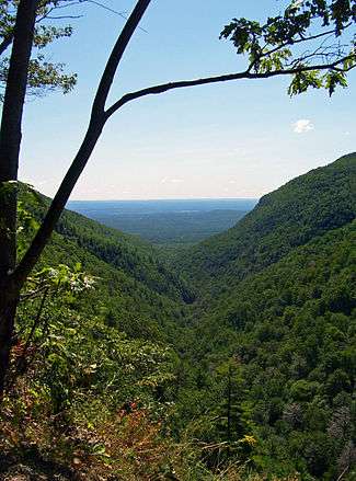
Platte Clove, sometimes Plattekill Clove, is a narrow and steep valley in the Catskill Mountains of New York. It is situated between Kaaterskill High Peak and Roundtop Mountain to the north and Plattekill Mountain and Indian Head Mountain to the south. It is mostly in Greene County, although the lowest, eastern portions are in Ulster County.
Along with Kaaterskill Clove on the other side of Kaaterskill High Peak, it is one of only two breaks in the Catskill Escarpment. The stream that runs below is called Plattekill Creek. A few hiking trails go through the Clove including Devil's Path and Huckleberry Point Trail. The Long Path, a 357 mi (575 km) long-distance hiking trail that starts near the George Washington Bridge and ends in Albany, NY, is contiguous with these trails. It comes from the south via Devil's Path, continues on the Overlook Trail, heads south on Platte Clove Rd. for 860 ft (262 m) and then heads north on Huckleberry Point Trail.
In the early 19th century, early American artists were struck by the rugged, wild scenery of the clove and other locations in the northeastern Catskills. Depictions of this wilderness by Thomas Cole and others led to the artists being dubbed the Hudson River School.
A narrow, two-lane road that climbs along the clove's north wall is the only route through it. This road, called Platte Clove Rd., runs from Blue Mountain Rd./ Harry Wells Rd. in West Saugerties, NY in the southeast until Rt 23A in Tannersville, NY in the northwest. The steepest section, which ascends up the side of the area called Devil's Kitchen, starts at the corner of Becker Rd. in West Saugerties, NY and climbs 1,200 vertical feet (366 m) in 2.1 miles (3.4 km) into Elka Park, NY. This section is renowned as one of the hardest climbs in the United States. It has an average grade of 11% and a maximum grade of 23%. The climb is categorized as a Hors catégorie climb, the hardest of all climbs, when including additional road heading further into Elka Park. The Devil's Kitchen climb itself is classified as a Category 2 climb, due to its shorter distance. The climb is as challenging, or more challenging, than some of the toughest climbs in the Tour de France[1]. Trucks and buses are banned from it throughout the year and all vehicle traffic is prohibited from it from November 1 to April 15, during which time it is not maintained or plowed. The Tour de Trump bicycle race was routed through here, and the road proved so steep that even some of the top bicyclists in the world had to get off and walk their bikes (it was raining that day). It also features prominently in the annual Tour of the Catskills[2] bike race. Aurelien Passeron, who won the 2010 Tour of the Catskills, said the climb was steeper than Col du Tourmalet in the Tour de France, Verbier, or even Mont Ventoux, but was shorter[1].
Devil's Kitchen got its name because the region is exceedingly difficult and dangerous. It runs from the top of the Platte Clove valley down into West Saugerties. The area is known to have a lot of Timber Rattlesnakes and Northern Copperheads. The south side is known to have hollow ground where you can fall through the ground into rock crevices. There are places where one can pull back a conifer branch and find a drop of over 100'. A number of years ago, a man died in a place called Hell's Hole and it took EMS personnel 3 days to remove his body.[3]
The cliffs near the clove's head-wall have views of the nearby waterfalls - but have also been the site of fatal accidents. In 2010, a man from the Albany suburb of Delmar lost his footing near one and fell 100 ft (30 m) to his death.[4] On June 4 of the same year, Olivia Rose Belfiglio fell 100 feet from the top of a cliff and died at the bottom.
In winter 1970 the body of a man was found on the slopes 50 feet (15 m) below Platte Clove Road a short distance past where it is closed at that time of year, near West Saugerties just short of the Greene County line. He carried no documents that would have identified him. The cause of death four gunshot wounds inflicted two days earlier; police believe he was killed elsewhere and disposed of in Platte Clove. His clothing and other items led them to theorize that he was from outside the U.S., possibly Europe or Brazil, and had possibly been lured to the country to be killed by organized crime without attracting too much attention in his native country; some local mobsters were interviewed about the case but did not provide any information. He remains unidentified; the New York State Police continue to investigate the case under the name West Saugerties John Doe.[5]
References
- 1 2 B, Jen (2010-08-02). "Frenchman Wins Tour of Catskills; Landis Ties for 11th". Benepe's Bike Blog (c). Retrieved 2018-09-13.
- ↑ "Tour of the Catskills". facebook.com. Retrieved 2018-09-13.
- ↑ "Catskillmountaineer.com Forum • View topic - Death at Devil's Kitchen". www.catskillmountaineer.com. Retrieved 2018-09-14.
- ↑ Campriello, Susan (May 1, 2010). "Delmar Hiker Killed Near Platte Clove Road". The Daily Mail. Journal Register Company. Retrieved May 2, 2010.
- ↑ Yakin, Heather (September 25, 2016). "Unsolved: Police still working West Saugerties case". Times Herald Record. Retrieved September 28, 2016.
http://www.dailyfreeman.com/articles/2010/06/06/news/doc4c0b22efc0df3258112272.txt http://www.dailyfreeman.com/articles/2010/09/15/news/doc4c904d90c4882152986556.txt http://www.catskillmountaineer.com/forums/phpBB-3.0.5/phpBB3/viewtopic.php?f=8&t=174&sid=79e999fd184425927bac63e601ee51b8 http://www.nbcnewyork.com/news/local/17-Year-Old-Upstate-Girl-Dies-Hiking-in-Catskills-95683214.html http://www.poststarnews.com/obituaries/x1980739104/Olivia-Rose-Belfiglio